eAtlas Data Catalogue
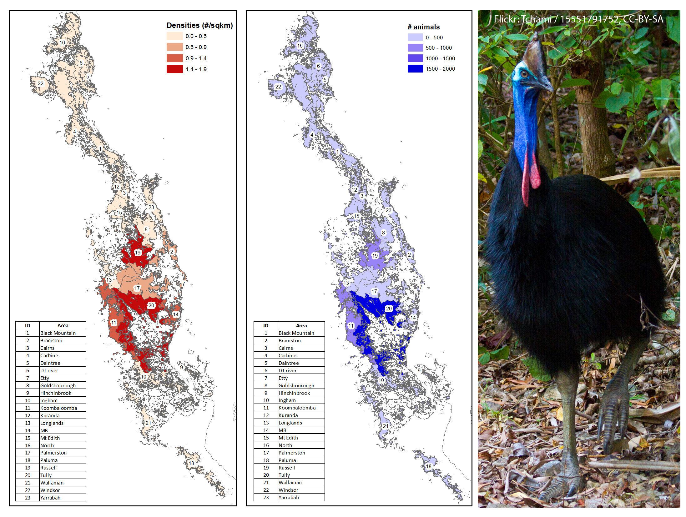
Distribution of cassowary (Casuarius casuarius) density and abundance in the Wet Tropics of Australia 2014 - 2014 (NERP TE 3.4, CSIRO)
This dataset contains the estimated distribution and abundance of cassowaries across the Wet Tropics Region and the sub-regions used in these estimates. The key areas for cassowary conservation are those with the highest densities and abundance.
This data is based on field surveys and data on cassowary density derived from faecal-DNA analysis of dung samples collected during those surveys.
Methods:
Surveys were conducted along 157 transects distributed across the Wet Tropics Region during 2012 - 2014. During these surveys all forms of cassowary sign were recorded and in the case of dung the dung was also collected. Cassowary DNA was extracted from the dung samples and DNA fingerprinting analysis was used to identify individuals. Based on the relationship between dung encounter rates and density of cassowaries at 8 focal sites, the density of cassowaries and their abundance on transects in each of 23 sub - regions was estimated.
The sub - regions were based on the estimated cassowary essential habitat. Essential habitat is based on verified sightings of the Southern Cassowary since 1980 and includes vegetation considered to be important for the species in terms of foraging, breeding or other parts of the species' life cycle. This habitat is considered to be necessary for the long-term survival of the cassowary. The important vegetation types associated with essential habitat (91 Regional Ecosystems) are listed within Kutt and colleagues (2004).
Further details of the methods are provided in the technical report for this work, Westcott (2014).
Limitations:
eAtlas Note: The original shapefile provided by the researchers has very fine boundary mapping from the cassowary essential habitat mapping. This is then broken down into 23 regions. The scale of these two datasets is vastly different and needs to be considered when using or interpreting this data.
A slightly lower resolution version of this data was prepared for download from the eAtlas. This reduces the fine scale habitat mapping slightly, whilst retaining the cassowary regional information. The mapping layer associated with this record corresponds to the original high resolution version.
Format:
Original Shapefile (452 polygons, 25 MB) of the 23 subregions of the Wet Tropics with estimated density and animal numbers. The detail of the region boundaries are based on very detailed estimated essential cassowary habitat mapping Kutt (2004).
Simplified Shapefile (23 polygons, 2.6 MB). This contains the same cassowary estimated density and animal numbers across the Wet Tropics except with simplified habitat mapping. This was derived from the original by dissolving polygons with the same data, then smoothing the polygon using a 150m filter, then simplifying the polygon with an allowable tolerance of 15 m and removing features smaller than 2 hectares. This shapefile was prepared by the eAtlas team. This simplified version is more suitable for large scale maps.
Data Dictionary:
- CassBound: Name of the cassowary mapping region
- CassDens: Estimated density of cassowary in animals per square km.
- Cass_num: Estimated number of cassowaries in region.
- Hectare: Area of the mapping region in Hectares.
References:
Kutt A. S, King S., Garnett S. T. & Latch P. (2004) Distribution of cassowary habitat in the wet tropics bioregion, Queensland. Technical Report to the Queensland Environmental Protection Agency. Environment Protection Agency, Brisbane, Queensland.
Westcott, D.A., Metcalfe, S., Jones, D., Bradford, M., McKeown, A., Ford, A. (2014) Estimation of the population size and distribution of the southern cassowary, Casuarius casuarius, in the Wet Tropics Region of Australia. Report to the National Environmental Research Program. Reef and Rainforest Research Centre Limited, Cairns (21pp.).
Simple
Identification info
- Date (Publication)
- 2015-01-13
- Cited responsible party
-
Role Organisation Name Telephone Delivery point City Administrative area Postal code Country Electronic mail address Principal investigator CSIRO Land and Water Flagship Westcott, David, Dr Voice Atherton Queensland 4883 Australia david.westcott@csiro.au Collaborator CSIRO Land and Water Flagship McKeown, Adam, Mr Voice Facsimile Smithfield Cairns Australia adam.mckeown@csiro.au
- Point of contact
-
Role Organisation Name Telephone Delivery point City Administrative area Postal code Country Electronic mail address Point of contact CSIRO Land and Water Flagship Westcott, David, Dr Voice Atherton Queensland 4883 Australia david.westcott@csiro.au
- Spatial representation type
- Vector
- Topic category
-
- Biota
Extent
Extent
- Description
- Wet Tropics

Temporal extent
- Time position
- 2012-01-01T00:00:00
- Time position
- 2014-12-31T00:00:00
Resource constraints
- Linkage
-
http://i.creativecommons.org/l/by/3.0/au/88x31.png
License Graphic
- Title
- Creative Commons Attribution 3.0 Australia License
- Cited responsible party
-
Role Organisation Name Telephone Delivery point City Administrative area Postal code Country Electronic mail address
- Website
-
http://creativecommons.org/licenses/by/3.0/au/
License Text
- Language
- English
- Character encoding
- UTF8
Distribution Information
- OnLine resource
- eAtlas Web Mapping Service (WMS) (AIMS)
- OnLine resource
- Project web site
- OnLine resource
- Original Shapefile (452 polygons, 25 MB) [Zip 18 MB]
- OnLine resource
- Interactive map of this dataset
- OnLine resource
- nerp:WT_NERP-TE-3-4_CSIRO_Cassowary-dist_2012-2014
Metadata constraints
- Linkage
-
http://i.creativecommons.org/l/by/3.0/au/88x31.png
License Graphic
- Title
- Creative Commons Attribution 3.0 Australia License
- Cited responsible party
-
Role Organisation Name Telephone Delivery point City Administrative area Postal code Country Electronic mail address
- Website
-
http://creativecommons.org/licenses/by/3.0/au/
License Text
Metadata
- Metadata identifier
- urn:uuid/0c26dc2e-2a64-4e9c-ad10-cdbf8ed7d758
- Language
- English
- Character encoding
- UTF8
- Contact
-
Role Organisation Name Telephone Delivery point City Administrative area Postal code Country Electronic mail address Point of contact Australian Institute of Marine Science (AIMS) eAtlas Data Manager Voice Facsimile PRIVATE MAIL BAG 3, TOWNSVILLE MAIL CENTRE Townsville Queensland 4810 Australia e-atlas@aims.gov.au
Type of resource
- Resource scope
- Dataset
- Metadata linkage
-
https://eatlas.org.au/data/uuid/0c26dc2e-2a64-4e9c-ad10-cdbf8ed7d758
Point of truth URL of this metadata record
- Date info (Creation)
- 2015-01-13T15:19:10
- Date info (Revision)
- 2026-02-18T07:09:31.445Z
Metadata standard
- Title
- ISO 19115-3:2018