eAtlas Data Catalogue
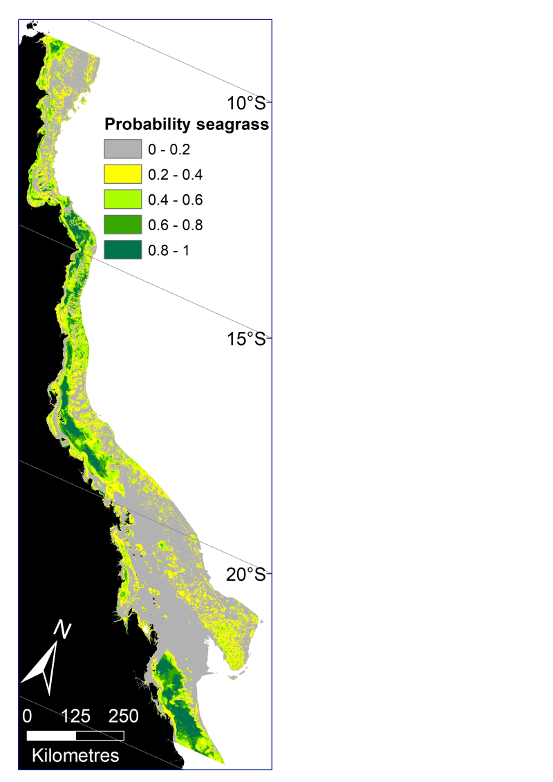
Predicted probability of seagrass presence across the Great Barrier Reef World Heritage Area and adjacent estuaries (NESP TWQ 5.4, TropWATER, James Cook University)
This dataset describes the predicted probability of seagrass presence across the Great Barrier Reef World Heritage Area and adjacent estuaries, based on six Random Forest models. The models have been mosaicked together into one raster dataset with 30m resolution.
Managing seagrass resources in the GBRWHA requires adequate information on the spatial extent of seagrass habitat. The enormous size of the GBRWHA (1000s of kilometres) and the remoteness of many seagrass meadows from human populations means that models are a useful tool to predict the probability of seagrass for areas where data is lacking.
James Cook University’s Centre for Tropical Water & Aquatic Ecosystem Research (TropWATER) has been collecting spatial data on GBR seagrass since the early 1980s. This project used TropWATER’s synthesis of seagrass site data (NESP Project 3.1 and 5.4: https://eatlas.org.au/data/uuid/5011393e-0db7-46ce-a8ee-f331fcf83a88) to predict potential seagrass habitat.
In making this data publically available for management, the authors from the TropWATER Seagrass Group request being contacted and involved in decision making processes that incorporate this data, to ensure its limitations are fully understood.
Methods:
Seagrass data
The sampling methods used to study, describe and monitors seagrass meadows were developed by the TropWATER Seagrass Group and tailored to the location and habitat surveyed; descriptions and references are available in the metadata for the GBRWHA data composite ( https://eatlas.org.au/data/uuid/5011393e-0db7-46ce-a8ee-f331fcf83a88 ).
Environmental data
Environmental predictors used in the models were: depth below mean sea level (Beaman 2017), relative tidal exposure (Bishop-Taylor et al. 2019), water type (Marine Water Bodies definitions version 2_4, Data courtesy of the Great Barrier Reef Marine Park Authority; Dyall et al. 2004), proportion mud in the sediment (coast and reef models, https://research.csiro.au/ereefs/models/model-outputs/access-to-raw-model-output/ ) (see also Baird et al. 2020; Margvelashvili et al. 2018), dominant sediment (estuary models only; https://eatlas.org.au/data/uuid/5011393e-0db7-46ce-a8ee-f331fcf83a88 ), benthic geomorphology (Heap and Harris 2008), benthic light https://dapds00.nci.org.au/thredds/catalog/fx3/gbr1_bgc_924/catalog.html (see also Baird et al. 2016; Baird et al. 2020), water temperature, mean current speed and salinity https://thredds.ereefs.aims.gov.au/thredds/catalog/ereefs/gbr1_2.0/all-one/catalog.html (Steven et al. 2019), wind speed ( https://thredds.ereefs.aims.gov.au/thredds/catalog/ereefs/gbr1_2.0/all-one/catalog.html ) and Australian Bureau of Meteorology’s ACCESS data products (Bureau of Meteorology 2020; Soldatenko et al. 2018; Steven et al. 2019), and latitude. Different models had different combinations of predictors after removing collinear variables and excluding variables that did not extend into an area. For example, estuary models only include depth, relative tidal exposure, dominant sediment, and latitude.
Models
We modelled seagrass probability in six areas: Estuary Intertidal, Estuary Subtidal, Coast Intertidal, Coast Subtidal, Reef Intertidal and Reef Subtidal. For each area we used the machine learning technique random forest to broadly examine whether there were habitats within the GBRWHA and adjacent estuaries where seagrass was never likely to grow, using the binary classification within the site data of seagrass present (1) or absent (0) irrespective of species. Random Forest models were implemented using the randomForest package (Liaw and Wiener 2002) in R version 4.0.2 (R Core Team 2020). We used ArcGIS 10.8 to mosaic the six rasters and create a single seagrass probability raster for the GBRWHA.
Spatial limits
Seagrass data north and south of the GBRWHA were not included in the analysis. The model extends across the continental shelf but excludes waters deeper than ~100m east of the shelf that were not surveyed for seagrass. Data were included when sites extended west of the GBRWHA boundary into coastal and estuarine water immediately adjacent.
Data sets
The site data used in this model is available here: https://eatlas.org.au/data/uuid/5011393e-0db7-46ce-a8ee-f331fcf83a88
Further information can be found in the upcoming publications of the final report for the NESP TWQ Project 5.4.
Limitation of the data:
The site data used in these models extends back to the mid-1980s. Large parts of the coast have not been mapped for seagrass presence since that time. The seagrass probability raster is at 30m grid resolution, however some environmental variables such as those from eReefs (wind speed, current speed, benthic light, water temperature) are from spatial data at 1km grid resolution, and are likely to vary at much smaller spatial scales that we could not include in these models.
Format:
This dataset consists of a raster dataset with a geographic coordinate system of WGS84. The raster has been saved as a layer package with symbology representing seagrass probability in 0.2 increments with a range of 0-1 (GBRWHA_seagrass_probability.lpk)
References:
TBC
Data Location:
This dataset is filed in the eAtlas enduring data repository at: data\custodian\2019-2022-NESP-TWQ-5\5.4_Seagrass-Burdekin-region
Additional licensing information:
TropWATER gives no warranty in relation to the data (including accuracy, reliability, completeness, currency or suitability) and accepts no liability (including without limitation, liability in negligence) for any loss, damage or costs (including consequential damage) relating to any use of the data. TropWATER reserves the right to update, modify or correct the data at any time. The limitations of some older data included need to be understood and recognised. The TropWATER Seagrass Group would appreciate the opportunity to review documents providing research, management, legislative or compliance advice based on this data.
Simple
Identification info
- Date (Creation)
- 2020-12-03
- Date (Publication)
- 2021-01-28T00:00:00
- Cited responsible party
-
Role Organisation Name Telephone Delivery point City Administrative area Postal code Country Electronic mail address Principal investigator James Cook University Carter, Alex alexandra.carter@jcu.edu.au Collaborator James Cook University Collier, Catherine Collaborator James Cook University Rasheed, Michael Collaborator Data61 Lawrence, Emma Collaborator Australian Institute of Marine Science Robson, Barbara Collaborator James Cook University Coles, Rob
- Point of contact
-
Role Organisation Name Telephone Delivery point City Administrative area Postal code Country Electronic mail address Point of contact James Cook University Carter, Alex alexandra.carter@jcu.edu.au
- Topic category
-
- Biota
Extent
Extent
- Description
- Great Barrier Reef, Australia

Resource constraints
- Linkage
-
http://i.creativecommons.org/l/by/3.0/au/88x31.png
License Graphic
- Title
- Creative Commons Attribution 3.0 Australia License
- Cited responsible party
-
Role Organisation Name Telephone Delivery point City Administrative area Postal code Country Electronic mail address
- Website
-
http://creativecommons.org/licenses/by/3.0/au/
License Text
- Other constraints
- This dataset should be cited as: Carter, A., Collier, C., Rasheed, M., Lawrence, E., Robson, B., & Cole, R. (2021). Predicted probability of seagrass presence across the Great Barrier Reef World Heritage Area and adjacent estuaries (NESP TWQ Project 5.4, TropWATER, JCU) [Data set]. eAtlas. https://doi.org/10.26274/J6B6-PH79
Associated resource
- Association Type
- Dependency
- Initiative Type
- Project
- Title
- NESP TWQ Project 5.4 - Deriving ecologically relevant targets to meet desired ecosystem condition for the Great Barrier Reef: A case study for seagrass meadows in the Burdekin region, 2019-2020 (JCU)
Identifier
- Language
- English
- Character encoding
- UTF8
Distribution Information
- OnLine resource
- NESP TWQ project site
- OnLine resource
- eAtlas Web Mapping Service (WMS) (AIMS)
- OnLine resource
- Project web site
- OnLine resource
- ArcGIS Layer Package + GeoTIFF + probability of seagrass map image + Metadata [Zip 377 MB]
- OnLine resource
- Interactive map of this dataset
Metadata constraints
- Linkage
-
http://i.creativecommons.org/l/by/3.0/au/88x31.png
License Graphic
- Title
- Creative Commons Attribution 3.0 Australia License
- Cited responsible party
-
Role Organisation Name Telephone Delivery point City Administrative area Postal code Country Electronic mail address
- Website
-
http://creativecommons.org/licenses/by/3.0/au/
License Text
Metadata
- Metadata identifier
- urn:uuid/108ee868-4fb1-4e5f-ae57-5d65198384cc
- Language
- English
- Character encoding
- UTF8
- Contact
-
Role Organisation Name Telephone Delivery point City Administrative area Postal code Country Electronic mail address Point of contact Australian Institute of Marine Science (AIMS) eAtlas Data Manager Voice Facsimile PRIVATE MAIL BAG 3, TOWNSVILLE MAIL CENTRE Townsville Queensland 4810 Australia e-atlas@aims.gov.au
Type of resource
- Resource scope
- Dataset
- Metadata linkage
-
https://eatlas.org.au/data/uuid/108ee868-4fb1-4e5f-ae57-5d65198384cc
Point of truth URL of this metadata record
- Date info (Creation)
- 2021-12-02T22:18:03
- Date info (Revision)
- 2026-02-18T06:59:41.877Z
Metadata standard
- Title
- ISO 19115-3:2018