eAtlas Data Catalogue
Vertical light profiling data (NESP TWQ 2.1.9, AIMS)
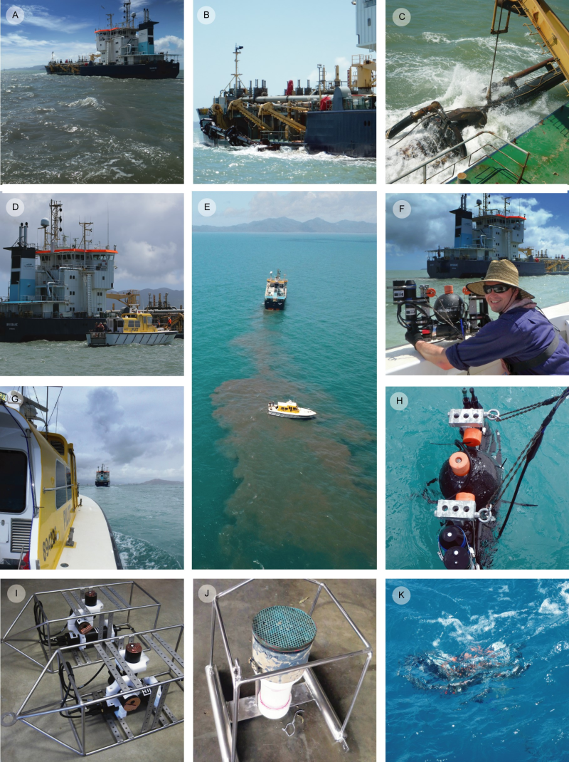
The aim of the study was to obtain light and turbidity vertical profile data through the water column in Cleveland Bay over a four-day period and during maintenance dredging to use for developing an empirical spectral solar irradiance model.
This dataset consists of 95 data files (spreadsheets). One file (.xlsx format) contains the spectral attenuation coefficient for downwelling light, Kd (lambda), for the 94 different vertical profiles taken within Cleveland Bay. In addition, individual raw data files from the USSIMO Hyperspectral Irradiance Sensor for each profile are provided (.csv format).
Methods:
Over a 4-d period (12–15 September 2016), and during a period of routine maintenance dredging, 94 light and turbidity vertical profiles were measured through the water column in Cleveland Bay using a USSIMO multispectral radiometer (In Situ Marine Optics, Perth, Australia) and IMO-NTU turbidity sensor. The USSIMO incorporates a Carl Zeiss UV/VIS miniature monolithic spectrometer module as the internal light recording device providing irradiance measurement values at nanometer spectral spacing.
For each vertical profile the irradiance just-below surface incident irradiance Ed (0-, lambda) and the light attenuation coefficient Kd (lambda) were determined using the Beer-Lambert law. These data were used to calculate the wavelength specific light attenuation coefficients for downwelling light, Kd (lambda), using the relationship,
E(lambda,z)=E(lambda,0) exp (-K_d (lambda),z)
Where: E (lambda,z) is the spectral downwelling irradiance at depth z, and E (lambda,0) is the spectral downwelling irradiance just below the ocean’s surface. The accelerometer in the USSIMO was used to assess if the instrument was vertical and stable and the first 0.2 m of all deployments was discarded prior to calculating Kd.
Kd values, along with the latitude and longitude for each station and the date and time of day the vertical profiling occurred can be found in the spreadsheet (.xlsx format). Each individual raw data file (.csv format) from the USSIMO sensor contains normalised Ed values (e.g. in-water Ed divided by above-water reference Ed), as well as the latitude and longitude for each station and the date and time of day the vertical profiling occurred.
Limitations of the data:
The value of NaN appears in the spreadsheet NewDataset1_ALL_Kd_DATA.xlsx for spectral attenuation coefficient for downwelling light, Kd (lambda). It describes values too low under highly turbid conditions to reliably calculate the Kd value.
Format:
This dataset contains a single Excel file with a size of 46 KB and 94 csv files ranging in size from 11 to 202 KB.
Data Dictionary:
Spreadsheet NewDataset1_ALL_Kd_DATA.xlsx
Row headings include: Date, Local Time, Latitude, Longitude, Station ID, vertically averaged Kd (550 nm).
The heading lambda(nm) [in cell A7] is noting that 400 to 700 below are wavelengths in nanometres (nm).
Data Location:
This dataset is filed in the eAtlas enduring data repository at: data\nesp2\2.1.9-Dredging-marine-response
Simple
Identification info
- Date (Creation)
- 2019-10-24
- Date (Publication)
- 2019-11-14T00:00:00
- Cited responsible party
-
Role Organisation Name Telephone Delivery point City Administrative area Postal code Country Electronic mail address Principal investigator Australian Institute of Marine Science (AIMS) Jones, Ross, Dr Voice facsimile Level 3, Indian Ocean Marine Research CentreThe University of Western AustraliaFairway Entry 4 Crawley Western Australia 6009 Australia r.jones@aims.gov.au Point of contact Australian Institute of Marine Science (AIMS) Jones, Ross, Dr Voice facsimile Level 3, Indian Ocean Marine Research CentreThe University of Western AustraliaFairway Entry 4 Crawley Western Australia 6009 Australia r.jones@aims.gov.au
- Point of contact
-
Role Organisation Name Telephone Delivery point City Administrative area Postal code Country Electronic mail address Point of contact Australian Institute of Marine Science (AIMS) eAtlas Data Manager Voice facsimile PRIVATE MAIL BAG 3, TOWNSVILLE MAIL CENTRE Townsville Queensland 4810 Australia e-atlas@aims.gov.au
- Topic category
-
- Biota
Extent
Extent
- Description
- Great Barrier Reef, Australia

Temporal extent
- Time period
- 2016-09-12 2016-09-15
Resource constraints
- Linkage
-
http://i.creativecommons.org/l/by/3.0/au/88x31.png
License Graphic
- Title
- Creative Commons Attribution 3.0 Australia License
- Cited responsible party
-
Role Organisation Name Telephone Delivery point City Administrative area Postal code Country Electronic mail address
- Website
-
http://creativecommons.org/licenses/by/3.0/au/
License Text
- Language
- English
- Character encoding
- UTF8
Distribution Information
- OnLine resource
- NESP TWQ Project page
- OnLine resource
- eAtlas Web Mapping Service (WMS) (AIMS)
- OnLine resource
- Project web site
Metadata constraints
- Linkage
-
http://i.creativecommons.org/l/by/3.0/au/88x31.png
License Graphic
- Title
- Creative Commons Attribution 3.0 Australia License
- Cited responsible party
-
Role Organisation Name Telephone Delivery point City Administrative area Postal code Country Electronic mail address
- Website
-
http://creativecommons.org/licenses/by/3.0/au/
License Text
Metadata
- Metadata identifier
- urn:uuid/274ef866-9cba-4c1c-92b8-05ba1b3e165d
- Language
- English
- Character encoding
- UTF8
- Contact
-
Role Organisation Name Telephone Delivery point City Administrative area Postal code Country Electronic mail address Point of contact Australian Institute of Marine Science (AIMS) eAtlas Data Manager Voice facsimile PRIVATE MAIL BAG 3, TOWNSVILLE MAIL CENTRE Townsville Queensland 4810 Australia e-atlas@aims.gov.au
Type of resource
- Resource scope
- Dataset
- Metadata linkage
-
https://eatlas.org.au/data/uuid/274ef866-9cba-4c1c-92b8-05ba1b3e165d
Point of truth URL of this metadata record
- Date info (Creation)
- 2019-11-20T05:58:03
- Date info (Revision)
- 2023-09-18T08:46:44
Metadata standard
- Title
- ISO 19115-3:2018