eAtlas Data Catalogue
GBR Coastal Management (Land use, management, economic, planning, biodiversity) metadata catalogue (NERP TE 9.4, JCU)
This dataset corresponds to a database of datasets that are relevant for the development of coastal development scenarios and impact assessments GBR. It corresponds to a list of all the datasets that were sourced as part of project 9.4. It contains basic information about each dataset along with the license that each dataset was obtained under and where the data can be sourced. This database is an excellent starting point for any others looking at obtaining data relevant for coastal management.
Methods:
Datasets were sourced from a large and various. They are presented in the database in their raw condition as downloaded or obtained. The database includes all metadata that was associated with them. The database is currently hosted on a server at the Centre of Excellence for Coral Reef Studies at James Cook University as is backed up weekly.
Format:
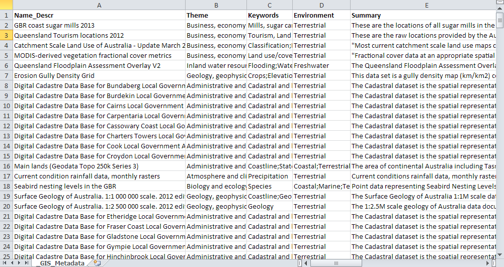
Coastal_zone_GIS_database.xlsx
This is an excel file containing name and full description of all datasets. Each row corresponds to a different GIS file (either shapefile or raster). When dataset can be downloaded from a website with or without an open access licence, the link is included. For others, the best contact point is included.
Simple
Identification info
- Date (Publication)
- 2015-01-19
- Cited responsible party
-
Role Organisation Name Telephone Delivery point City Administrative area Postal code Country Electronic mail address Principal investigator Australian Research Council Centre of Excellence for Coral Reef Studies (JCU) Augé, Amélie, Dr Voice James Cook University Townsville Queensland 4811 Australia amelie.auge@jcu.edu.au Collaborator Australian Research Council Centre of Excellence for Coral Reef Studies (JCU) Pressey, Bob, Prof. Voice James Cook University Townsville Queensland 4811 Australia bob.pressey@jcu.edu.au
- Point of contact
-
Role Organisation Name Telephone Delivery point City Administrative area Postal code Country Electronic mail address Point of contact Australian Research Council Centre of Excellence for Coral Reef Studies (JCU) Augé, Amélie, Dr Voice James Cook University Townsville Queensland 4811 Australia amelie.auge@jcu.edu.au
- Spatial representation type
- Text, table
- Topic category
-
- Planning cadastre
Extent
Extent
- Description
- Great Barrier Reef, Australia

Temporal extent
- Time position
- 2013-01-01T00:00:00
- Time position
- 2013-12-31T00:00:00
- Keywords (Theme)
-
- marine
Resource constraints
- Linkage
-
http://i.creativecommons.org/l/by/3.0/au/88x31.png
License Graphic
- Title
- Creative Commons Attribution 3.0 Australia License
- Cited responsible party
-
Role Organisation Name Telephone Delivery point City Administrative area Postal code Country Electronic mail address
- Website
-
http://creativecommons.org/licenses/by/3.0/au/
License Text
- Language
- English
- Character encoding
- UTF8
Distribution Information
- OnLine resource
- Project web site
- OnLine resource
- Excel spreadsheet with 358 metadata records as rows [Zip 510 kB]
Metadata constraints
- Linkage
-
http://i.creativecommons.org/l/by/3.0/au/88x31.png
License Graphic
- Title
- Creative Commons Attribution 3.0 Australia License
- Cited responsible party
-
Role Organisation Name Telephone Delivery point City Administrative area Postal code Country Electronic mail address
- Website
-
http://creativecommons.org/licenses/by/3.0/au/
License Text
Metadata
- Metadata identifier
- urn:uuid/4873eb39-c41e-431b-a2b7-159f02961fd2
- Language
- English
- Character encoding
- UTF8
- Contact
-
Role Organisation Name Telephone Delivery point City Administrative area Postal code Country Electronic mail address Point of contact Australian Institute of Marine Science (AIMS) eAtlas Data Manager Voice facsimile PRIVATE MAIL BAG 3, TOWNSVILLE MAIL CENTRE Townsville Queensland 4810 Australia e-atlas@aims.gov.au
- Parent metadata
Type of resource
- Resource scope
- Dataset
- Metadata linkage
-
https://eatlas.org.au/data/uuid/4873eb39-c41e-431b-a2b7-159f02961fd2
Point of truth URL of this metadata record
- Date info (Creation)
- 2015-07-01T20:25:57
- Date info (Revision)
- 2023-09-18T08:44:40
Metadata standard
- Title
- ISO 19115-3:2018