eAtlas Data Catalogue
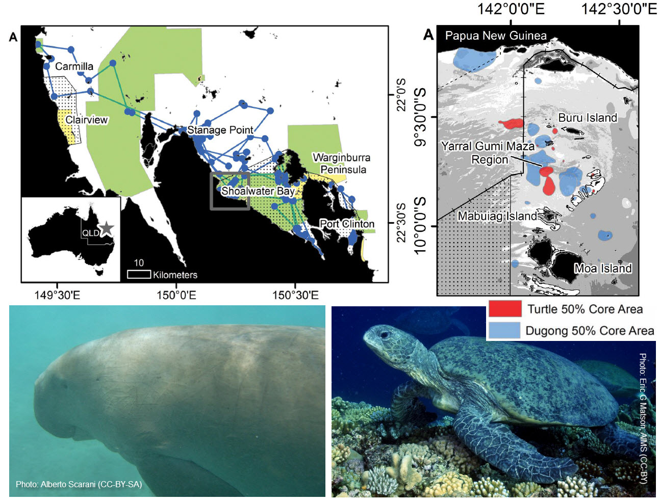
Satellite Tracking of Dugongs and Green Turtles in Torres Strait and Shoalwater Bay (NERP TE 1.2, 2.1, JCU)
This dataset consists of the home ranges and satellite tracks taken from eleven dugongs and ten green turtles.
Methods:
Fast-acquisition satellite telemetry was used to track eleven dugongs and ten green turtles at two geographically distinct foraging locations in Queensland, Australia to evaluate the inter- and intra-species spatial relationships and assess the efficacy of existing protection zones. Home-range analysis and bathymetric modeling were used to determine spatial use and compared with existing protection areas using GIS.
Raw, unfiltered tracking data were collected using fast acquisition GPS satellite transmitters attached to six dugongs (three females and three males) and four adult female green sea turtles near Mabuiag Island, Torres Strait, Australia in July 2009 and September 2010, and five dugongs (four females and one male) and six female green sea turtles (five adults and one prepubescent) in Shoalwater Bay, Australia in June/July 2012.
The dugongs were captured using the dermal hold fast technique in Torres Strait and the standard rodeo technique in Shoalwater Bay. At both locations, the dugongs were fitted with Telonics Gen 4 GPS/ARGOS marine units attached to a 3 m tether linked to a padded tailstock harness.
The green turtles were captured using the standard rodeo technique, brought to Mabuiag Island (Torres Strait) or
MacDonald Point (Shoalwater Bay), and fitted with one of four types of satellite transmitters (Sirtrack F4G 291A, Wildlife Computers SPLASH10 BF-273A and Splash10 BF-273C, or SMRU SRDL 9000x). Each transmitter was attached to the
carapace using the methods described in Shimada et al. (2012). Each turtle was released from shore the day after capture.
Dugong units were programmed to collect a GPS position hourly; turtle units every 30 minutes. All units were programmed with a five minute repeat in case a signal was not received when the animal surfaced.
Home-ranges were calculated for each animal using data from the entire period in which they were tracked and were calculated using fixed kernel density estimation with bandwidths selected by likelihood cross-validation (CVh). Kernel densities and bandwidths were calculated using the Geospatial Modelling Environment (GME), an extension to ArcGIS, with a resolution of 50 m.
For a more detailed description of the methods see Gredzens(2014).
Format:
This dataset consists of shapefiles for the satellite tracks (lines and points) for the 21 animals as well as shapefiles for the calculated home ranges.
References:
Gredzens C, Marsh H, Fuentes MMPB, Limpus CJ, Shimada T, et al. (2014) Satellite Tracking of Sympatric Marine Megafauna Can Inform the Biological Basis for Species Co-Management. PLoS ONE 9(6): e98944. doi:10.1371/journal.pone.0098944
Data Location:
This dataset is filed in the eAtlas enduring data repository at: data\NERP-TE\1.2_GBR-Turtles-dugong-monitoing
Change log:
2024-05-29 - Added interactive map of the resource link to Layer id: ea_nerp:TS_QLD_NERP-1-2-2-1_JCU_Turtle-dugong-tracking_2009-2012
Simple
Identification info
- Date (Publication)
- 2015-02-12
- Cited responsible party
-
Role Organisation Name Telephone Delivery point City Administrative area Postal code Country Electronic mail address Principal investigator James Cook University Gredzens, Christian Christian.Gredzens@my.jcu.edu.au Principal investigator James Cook University Hamann, Mark Mark.Hamann@jcu.edu.au Collaborator James Cook University Marsh, Helene Collaborator ARC Centre of Excellence for Coral Reef Studies Fuentes, Mariana Collaborator Queensland Department of Environment and Heritage Protection Limpus, Colin
- Point of contact
-
Role Organisation Name Telephone Delivery point City Administrative area Postal code Country Electronic mail address Point of contact James Cook University Gredzens, Christian Christian.Gredzens@my.jcu.edu.au
- Spatial representation type
- Vector
- Topic category
-
- Biota
Extent
Extent
- Description
- Torres Strait
- Extent type code
- false

Temporal extent
- Time position
- 2009-07-01T00:00:00
- Time position
- 2010-09-30T00:00:00
Extent
Extent
- Description
- Shoalwater Bay
- Extent type code
- false

Temporal extent
- Time position
- 2012-06-01T00:00:00
- Time position
- 2012-07-31T00:00:00
- Keywords (Theme)
-
- marine
Resource constraints
- Linkage
-
http://i.creativecommons.org/l/by/3.0/au/88x31.png
License Graphic
- Title
- Creative Commons Attribution 3.0 Australia License
- Cited responsible party
-
Role Organisation Name Telephone Delivery point City Administrative area Postal code Country Electronic mail address
- Website
-
http://creativecommons.org/licenses/by/3.0/au/
License Text
Associated resource
- Association Type
- Dependency
- Initiative Type
- Project
- Title
- NERP TE Project 1.2 - Marine wildlife management in the Great Barrier Reef World Heritage Area, 2011-2014 (JCU)
Identifier
- Language
- English
- Character encoding
- UTF8
Distribution Information
- OnLine resource
- Project web site (NERP TE 1.2)
- OnLine resource
- Project web site (NERP TE 2.1)
- OnLine resource
- Shapefiles of tracks, points and home ranges of animals in this dataset [Shapefile Zip 11.8 MB]
- OnLine resource
- Interactive map of the resource
Metadata
- Metadata identifier
- urn:uuid/73f2acfd-1cb7-48a5-a3e4-bad38939e4e9
- Language
- English
- Character encoding
- UTF8
- Contact
-
Role Organisation Name Telephone Delivery point City Administrative area Postal code Country Electronic mail address Point of contact Australian Institute of Marine Science (AIMS) eAtlas Data Manager Voice PRIVATE MAIL BAG 3, TOWNSVILLE MAIL CENTRE Townsville Queensland 4810 Australia e-atlas@aims.gov.au
- Parent metadata
Type of resource
- Resource scope
- Dataset
- Metadata linkage
-
https://eatlas.org.au/data/uuid/73f2acfd-1cb7-48a5-a3e4-bad38939e4e9
Point of truth URL of this metadata record
- Date info (Creation)
- 2016-08-02T15:36:56
- Date info (Revision)
- 2024-05-29T05:45:15
Metadata standard
- Title
- ISO 19115-3:2018