eAtlas Data Catalogue
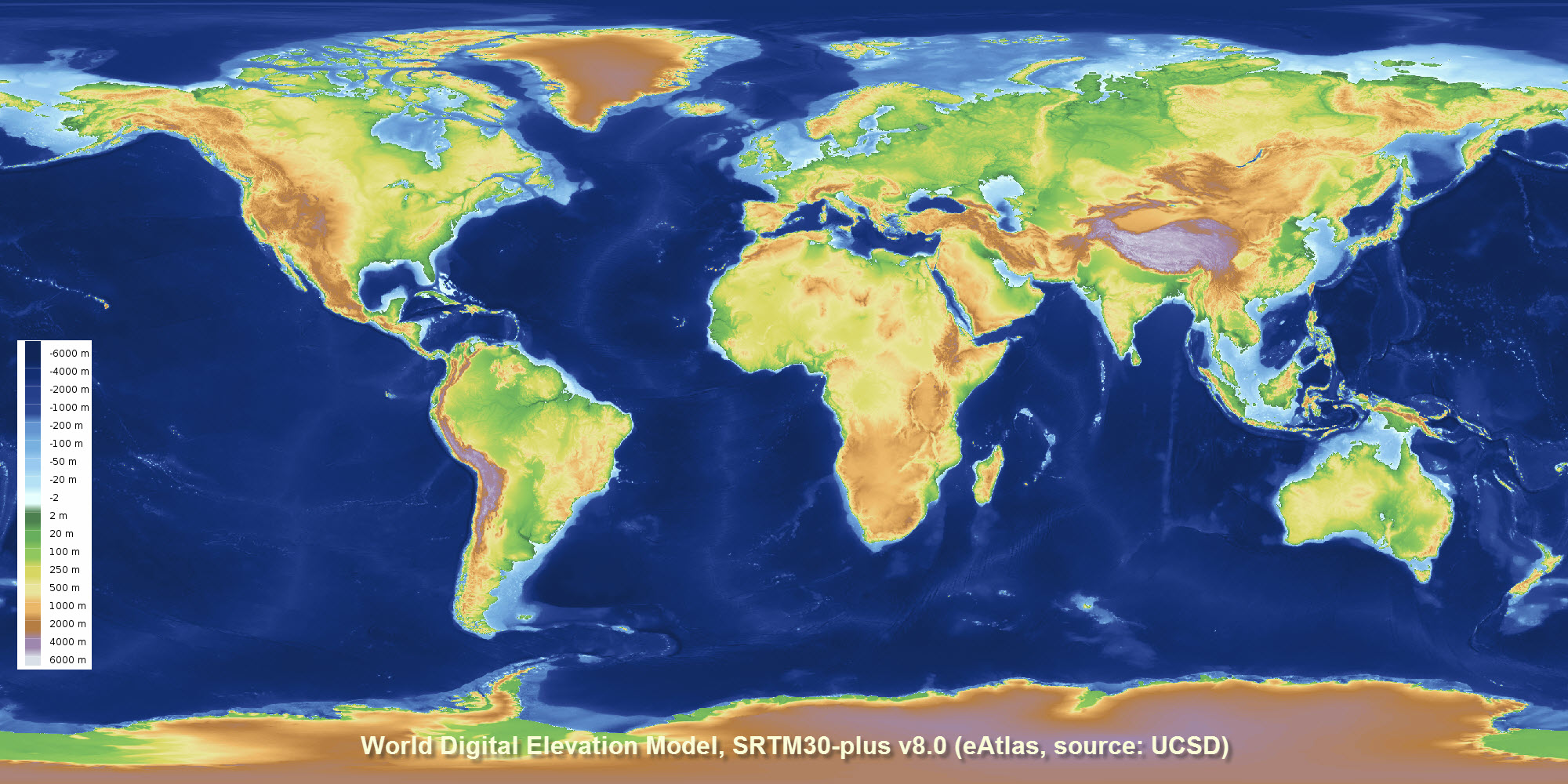
Global Bathymetry and Elevation Digital Elevation Model: SRTM30_PLUS v8 (30 arc sec, 1 km) reformatted as single GeoTiff (NERP TE 13.1 eAtlas, source: UCSD)
This dataset corresponds to a reformatting of the SRTM30_PLUS digital elevation dataset from 33 NetCDF files into a single GeoTiff for use in GIS applications. No other modifications to the data were done. The rest of this metadata describes the original SRTM30_PLUS dataset itself.
Note: The SRTM15_plus dataset is a similar more recent, higher resolution bathymetry dataset https://topex.ucsd.edu/WWW_html/srtm15_plus.html .
This dataset is a 30-arc second resolution global topography/bathymetry grid (SRTM30_PLUS) developed from a wide variety of data sources. Land and ice topography comes from the SRTM30 and ICESat topography, respectively. Ocean bathymetry is based on a new satellite-gravity model where the gravity-to-topography ratio is calibrated using 298 million edited soundings. The main contribution of this dataset is the compilation and editing of the raw soundings, which come from NOAA, individual scientists, SIO, NGA, JAMSTEC, IFREMER, GEBCO, and NAVOCEANO.
The SRTM30_PLUS dataset developed by Scripps Institute Of Oceanography, University of California San Diego (UCSD).
Land data are based on the 1-km averages of topography derived from the USGS SRTM30 grided DEM data product created with data from the NASA Shuttle Radar Topography Mission. GTOPO30 data are used for high latitudes where SRTM data are not available.
Ocean data are based on the Smith and Sandwell global 1-minute grid between latitudes +/- 81 degrees. Higher resolution grids have been added from the LDEO Ridge Multibeam Synthesis Project, the JAMSTEC Data Site for Research Cruises, and the NGDC Coastal Relief Model. Arctic bathymetry is from the International Bathymetric Chart of the Oceans (IBCAO) [Jakobsson et al., 2003].
This data consists of 33 files of global topography in the same format as the SRTM30 products distributed by the USGS EROS data center. The grid resolution is 30 second which is roughly one kilometer. In addition the global data are also available in a single large file ready for GMT and as 33 NetCDF files. The eAtlas has also merged and formatted the data as a single GeoTiff file with overviews (1.6 GB).
The pixel-registered data are stored in 33 files with names corresponding to the upper left corner of the array shown below. The data are also merged into a single large (1.9 Gbyte, 2-byte integer) file as well as smaller 1-minute and 2-minute netcdf versions. Matching files of source identification number are available for determining the data source for every pixel.
This new version (v8.0) includes all of the multibeam bathymetry data collected by U.S. research vessels over the past three decades including 287 Scripps expeditions from research vessels Washington, Melville and Revelle. UCSD undergraduate student Alexis Shakas processed all the U.S. multibeam data and then worked with Google researchers on the global integration.
The data is available from UCSD FTP server as 33 NetCDF files and from the eAtlas as a merged GeoTiff.
If you are after high resolution bathymetry/elevation data for regional areas please check the related links.
Reference, sounding data:
Becker, J. J., D. T. Sandwell, W. H. F. Smith, J. Braud, B. Binder, J. Depner, D. Fabre, J. Factor, S. Ingalls, S-H. Kim, R. Ladner, K. Marks, S. Nelson, A. Pharaoh, R. Trimmer, J. Von Rosenberg, G. Wallace, P. Weatherall., Global Bathymetry and Elevation Data at 30 Arc Seconds Resolution: SRTM30_PLUS, Marine Geodesy, 32:4, 355-371, 2009. http://topex.ucsd.edu/sandwell/publications/124_MG_Becker.pdf
Reference, gravity data:
Sandwell, D. T., and W. H. F. Smith, Global marine gravity from retracked Geosat and ERS-1 altimetry: Ridge Segmentation versus spreading rate, J. Geophys. Res., 114, B01411, doi:10.1029/2008JB006008, 2009. http://dx.doi.org/10.1029/2008JB006008
eAtlas Processing:
A set of Batch scripts were developed to perform the conversion of the data from NetCDF to GeoTiff and the generation of the hillshading. This processing was based on the GDAL command line tools. Full details of the processing can be found in the downloadable Scripts associated with this dataset.
Data Location:
This dataset is filed in the eAtlas enduring data repository at: data\NERP-TE\13.1_eAtlas\World_UCSD_SRTM30-plus
Simple
Identification info
- Date (Revision)
- 2012-10-23T00:00:00
- Cited responsible party
-
Role Organisation Name Telephone Delivery point City Administrative area Postal code Country Electronic mail address Custodian Scripps Institution Of Oceanography, University of California San Diego Voice facsimile 9500 Gilman Drive La Jolla 92093-0225 Principal investigator University of California Sandwell, David Principal investigator University of California Becker, Joseph Principal investigator University of California Smith, Walter
- Credit
- Becker, J. J., D. T. Sandwell, W. H. F. Smith, J. Braud, B. Binder, J. Depner, D. Fabre, J. Factor, S. Ingalls, S-H. Kim, R. Ladner, K. Marks, S. Nelson, A. Pharaoh, R. Trimmer, J. Von Rosenberg, G. Wallace, P. Weatherall
- Status
- Completed
- Spatial representation type
- Grid
Spatial resolution
Equivalent scale
- Denominator
- 2000000
- Topic category
-
- Elevation
Extent
Extent
))
- Keywords (Theme)
-
- marine
Resource constraints
- Linkage
-
http://i.creativecommons.org/l/by/3.0/au/88x31.png
License Graphic
- Title
- Creative Commons Attribution 3.0 Australia License
- Cited responsible party
-
Role Organisation Name Telephone Delivery point City Administrative area Postal code Country Electronic mail address
- Website
-
http://creativecommons.org/licenses/by/3.0/au/
License Text
- Language
- English
- Character encoding
- UTF8
Distribution Information
- OnLine resource
- Source data: SRTM PLUS Global Topography page (UCSD).
- OnLine resource
- Source data: UCSD FTP SRTM30 PLUS - 33 NetCDF files
- OnLine resource
- ea:World_e-Atlas-UCSD_SRTM30-plus_v8
- OnLine resource
- eAtlas Web Mapping Service (WMS) (AIMS)
- OnLine resource
- eAtlas project page
- OnLine resource
- Related dataset: GBR 100 m grid (gbr100) dataset
- OnLine resource
- SRTM30_PLUS v8.0 Hillshading Low Resolution [GeoTiff 81 MB]
- OnLine resource
- SRTM30_PLUS v8.0 Hillshading Full Resolution [GeoTiff 263 MB]
Reference System Information
- Reference system identifier
- EPSG/EPSG:4326
Metadata
- Metadata identifier
- urn:uuid/80301676-97fb-4bdf-b06c-e961e5c0cb0b
- Language
- English
- Character encoding
- UTF8
- Contact
-
Role Organisation Name Telephone Delivery point City Administrative area Postal code Country Electronic mail address Point of contact Australian Institute of Marine Science (AIMS) eAtlas Data Manager Voice facsimile PRIVATE MAIL BAG 3, TOWNSVILLE MAIL CENTRE Townsville Queensland 4810 Australia e-atlas@aims.gov.au
- Parent metadata
Type of resource
- Resource scope
- Dataset
- Metadata linkage
-
https://eatlas.org.au/data/uuid/80301676-97fb-4bdf-b06c-e961e5c0cb0b
Point of truth URL of this metadata record
- Date info (Creation)
- 2016-08-02T13:39:24
- Date info (Revision)
- 2023-09-18T09:10:18
Metadata standard
- Title
- ISO 19115-3:2018