eAtlas Data Catalogue
Bright Earth eAtlas Basemap (NERP TE 13.1 eAtlas, AIMS)
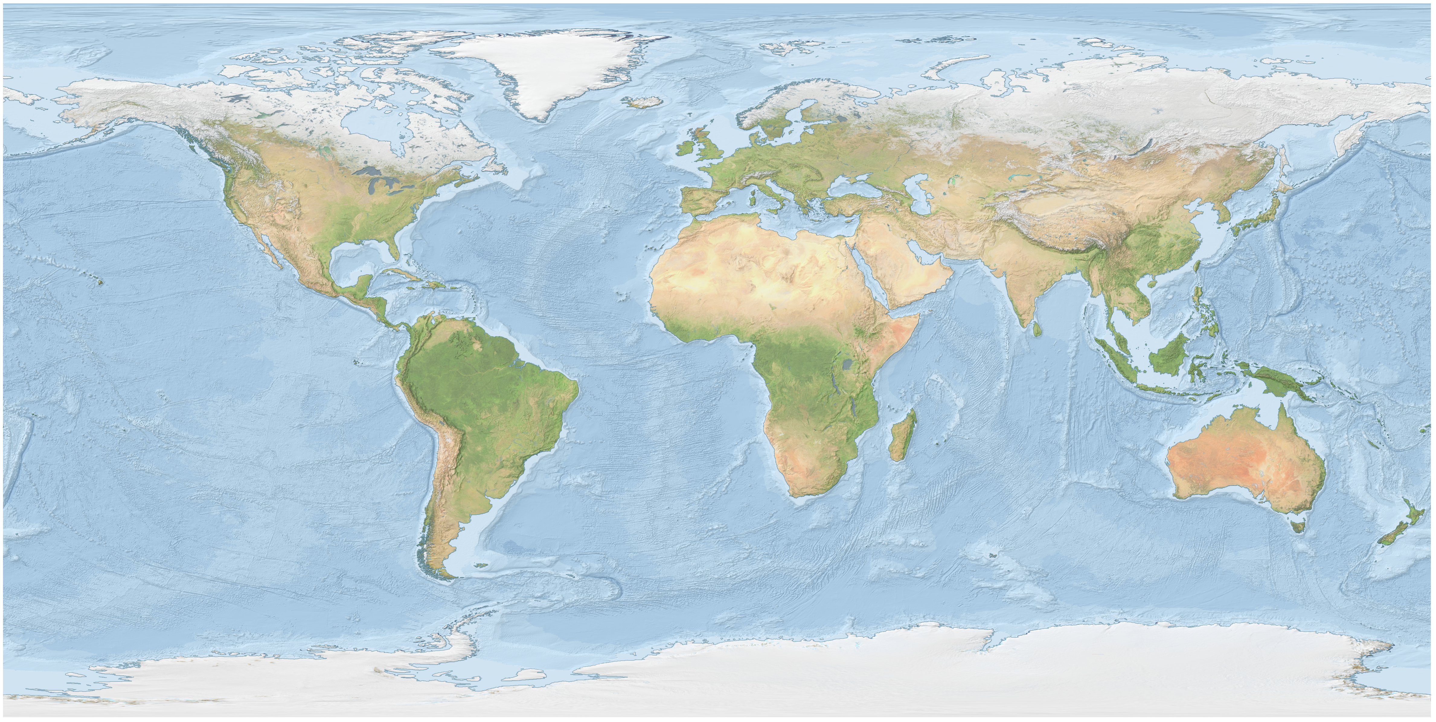
The Bright Earth eAtlas Basemap dataset collection is a satellite-derived global map of the world at a 1:1M scale for most of the world and 1:200k scale for Australia. This map was inspired by Natural Earth II (NEII) and NASA's Blue Marble Next Generation (BMNG) imagery.
Its aim was to provide a basemap similar to NEII but with a higher resolution (~10x).
This basemap is derived from the following datasets: Blue Marble Next Generation 2004-04 (NASA), VMap0 coastline, Coast100k 2004 Australian coastline (GeoScience Australia), SRTM30 Plus v8.0 (UCSD) hillshading, Natural Earth Vector 10m bathymetry and coastline v2.0 (NE), gbr100 hillshading (JCU).
This dataset (World_Bright-Earth-e-Atlas-basemap) contains all the files required to setup the Bright Earth eAtlas basemap in a GeoServer. All the data files are stored in GeoTiffs or shapefiles and so can also be loaded into ArcMap, however no styling has been included for this purpose.
This basemap is small enough (~900 MB) that can be readily used locally or deployed to a GeoServer.
Base map aesthetics (added 28 Jan 2025)
The Bright Earth e-Atlas Basemap is a high-resolution representation of the Earth's surface, designed to depict global geography with clarity, natural aesthetics with bright and soft color tones that enhance data overlays without overwhelming the viewer. The land areas are based on NASA's Blue Marble imagery, with modifications to lighten the tone and apply noise reduction filtering to soften the overall coloring. The original Blue Marble imagery was based on composite satellite imagery resulting in a visually appealing and clean map that highlights natural features while maintaining clarity and readability. Hillshading has been applied across the landmasses to enhance detail and texture, bringing out the relief of mountainous regions, plateaus, and other landforms.
The oceans feature three distinct depth bands to illustrate shallow continental areas, deeper open ocean zones, and the very deep trenches and basins. The colors transition from light blue in shallow areas to darker shades in deeper regions, giving a clear sense of bathymetric variation. Hillshading has also been applied to the oceans to highlight finer structures on the seafloor, such as ridges, trenches, and other geological features, adding depth and dimensionality to the depiction of underwater topography.
At higher zoom levels prominent cities are shown and the large scale roads are shown for Australia.
Rendered Raster Version (added 28 Jan 2025)
A low resolution version of the dataset is available as a raster file (PNG, JPG and GeoTiff) at ~2 km and 4 km resolutions. These rasters are useful for applications where GeoServer is not available to render the data dynamically. While the rasters are large they represent a small fraction of the full detail of the dataset. The rastered version was produced using the layout manager in QGIS to render maps of the whole world, pulling the imagery from the eAtlas GeoServer. This imagery from converted to the various formats using GDAL. More detail is provided in 'Rendered-bright-earth-processing.txt' in the download and browse section.
Change Log
2025-01-28: Added two rendered raster versions of the dataset at 21600x10800 and 10400x5400 pixels in size in PNG, JPG and GeoTiff format. Added
Simple
Identification info
- Alternate title
- World_Bright-Earth-e-Atlas-basemap
- Date (Publication)
- 2013-07-31T08:54:00
- Date (Revision)
- 2025-01-25
- Cited responsible party
-
Role Organisation Name Telephone Delivery point City Administrative area Postal code Country Electronic mail address Principal investigator Australian Institute of Marine Science Lawrey, Eric e-atlas@aims.gov.au
- Purpose
- The aim of this dataset collection was to create a global basemap that can be used by the eAtlas and others and have sufficient resolution to visualise datasets on the GBR.
- Status
- Completed
- Point of contact
-
Role Organisation Name Telephone Delivery point City Administrative area Postal code Country Electronic mail address Point of contact Australian Institute of Marine Science Lawrey, Eric e-atlas@aims.gov.au
- Spatial representation type
- Vector
Spatial resolution
Equivalent scale
- Denominator
- 1000000
- Topic category
-
- Imagery base maps earth cover
Extent
Extent
))
- Keywords (Theme)
-
- Oceans | Bathymetry | Seafloor Topography
- Land Surface | Topography | Relief
- marine
Resource constraints
- Use limitation
- All the new source material (stylings, GeoServer configuration, this file) produced by the eAtlas is made available under a Creative Commons Attribution 3.0 Australia Licence (http://creativecommons.org/licenses/by/3.0/au/deed.en), however for the source datasets used to make the basemap each have their own license that must be followed. For more information on this see the readme.txt bundled with the download of the Bright Earth dataset.
- Linkage
-
http://i.creativecommons.org/l/by/2.5/au/88x31.png
License Graphic
- Title
- Creative Commons Attribution 2.5 Australia License
- Cited responsible party
-
Role Organisation Name Telephone Delivery point City Administrative area Postal code Country Electronic mail address
- Website
-
http://creativecommons.org/licenses/by/2.5/au/
License Text
- Other constraints
- To cite this dataset in a printed document: Lawrey, Eric. (2013), Bright Earth eAtlas Basemap v1.0 (AIMS, GBRMPA, JCU, DSITIA, GA, UCSD, NASA, OSM, ESRI). [publisher] eAtlas. [Data files] License: Creative Commons Attribution 3.0 Australia. Available https://eatlas.org.au/data/uuid/ac57aa5a-233b-4c2c-bd52-1fb40a31f639 To cite in the legend of a printed map: Bright Earth eAtlas basemap v1.0 (AIMS, GBRMPA, JCU, DSITIA, GA, UCSD, NASA, OSM, ESRI), CC BY AU 3.0 or "Bright Earth eAtlas basemap v1.0 (AIMS)" if you are really squeezed for space. To cite in a web map use code similar to: <a href="https://eatlas.org.au/data/uuid/ac57aa5a-233b-4c2c-bd52-1fb40a31f639" target="_blank">Bright Earth eAtlas Basemap v1.0</a> (AIMS, GBRMPA, JCU, DSITIA, GA, UCSD, NASA, OSM, ESRI) <a href="http://creativecommons.org/licenses/by/3.0/au/">CC BY</a>
Associated resource
- Association Type
- Dependency
- Initiative Type
- Project
- Title
- NERP TE Project 13.1 - e-Atlas, 2011-2014 (AIMS)
Identifier
- Language
- English
- Character encoding
- UTF8
Distribution Information
- OnLine resource
- ea-be:World_Bright-Earth-e-Atlas-basemap
- OnLine resource
- Interactive map of this dataset
- OnLine resource
- eAtlas Web Mapping Service (WMS) (AIMS)
- OnLine resource
- eAtlas project page
- OnLine resource
- Dataset Readme.txt - Includes detailed licensing information.
- OnLine resource
-
Browse and Download
Vector files for GeoServer [897 MB Zip] and rastered versions [21600x10800 and 10800x5400 pixels in PNG, JPRG and GeoTiff])
Reference System Information
- Reference system identifier
- EPSG/EPSG:4326
Metadata
- Metadata identifier
- urn:uuid/ac57aa5a-233b-4c2c-bd52-1fb40a31f639
- Language
- English
- Character encoding
- UTF8
- Contact
-
Role Organisation Name Telephone Delivery point City Administrative area Postal code Country Electronic mail address Point of contact Australian Institute of Marine Science eAtlas Data Manager Voice PRIVATE MAIL BAG 3, TOWNSVILLE MAIL CENTRE Townsville Queensland 4810 Australia e-atlas@aims.gov.au
- Parent metadata
Type of resource
- Resource scope
- Dataset
- Metadata linkage
-
https://eatlas.org.au/data/uuid/ac57aa5a-233b-4c2c-bd52-1fb40a31f639
Point of truth URL of this metadata record
- Date info (Creation)
- 2020-04-21T04:41:35
- Date info (Revision)
- 2025-01-28T06:10:44.669Z
Metadata standard
- Title
- ISO 19115-3:2018