eAtlas Data Catalogue
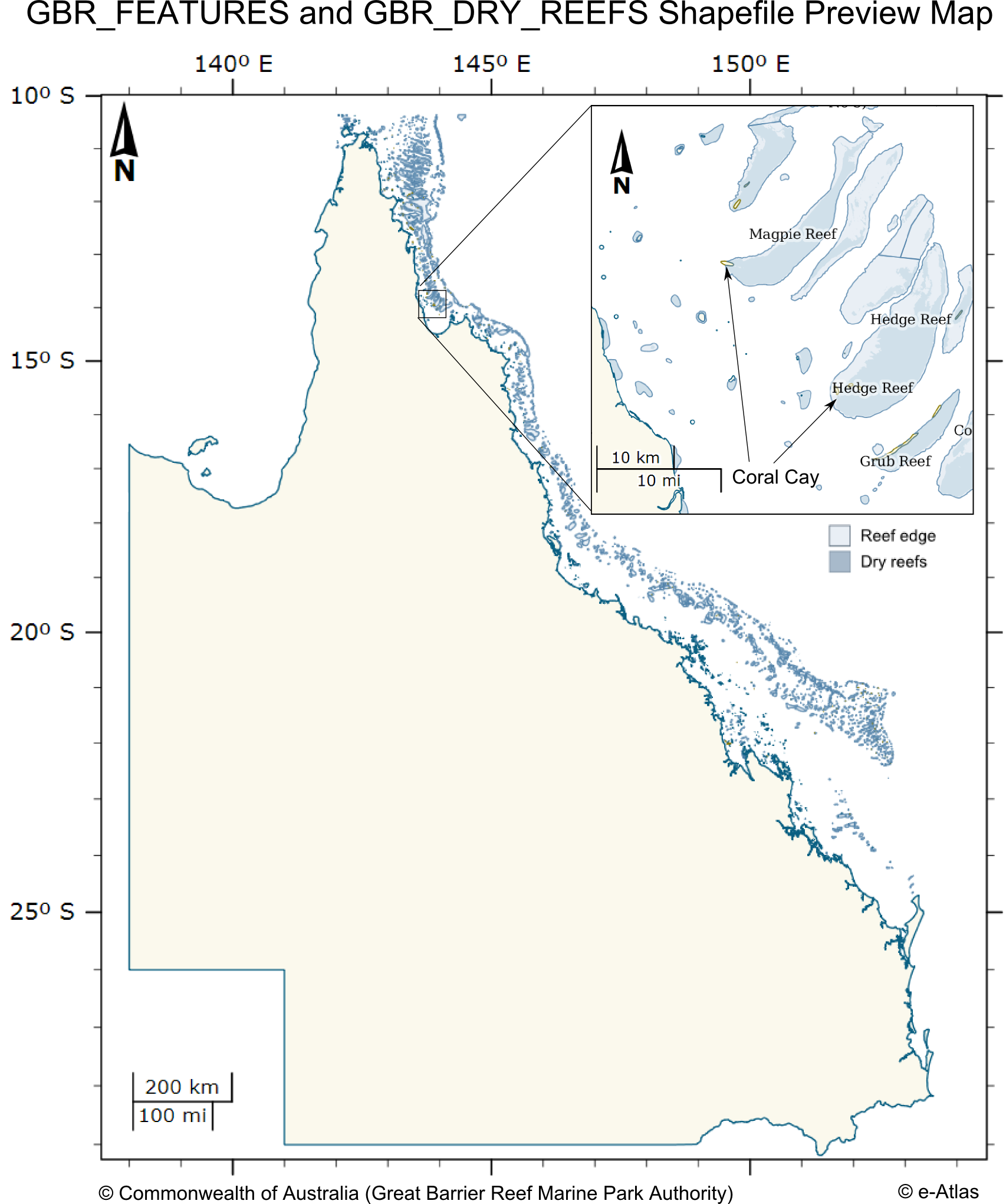
Great Barrier Reef (GBR) Features (Reef boundaries, QLD Mainland, Islands, Cays, Rocks and Dry Reefs) (GBRMPA)
This dataset contains coastal features within and adjacent to the Great Barrier Reef World Heritage area. This dataset consists of two shapefiles GBR_FEATURES.shp and GBR_DRY_REEF.shp. The GBR_FEATURES shapefile contains the following features:
* Queensland mainland coastline,
* Major and other coral reef structures (as defined by the reef shoal edge),
* Islands and rocks (exposed and submerged),
* Major coral cay features.
The GBR_DRY_REEFS contains major coral reef structures (as defined by the reef shoal edge) that are tidal, drying or emergent reef areas.
The reef features extend north above the GBRWHA to just within the Torres Strait region.
The features have not been statistically tested with precision survey techniques. Positional accuracy varies considerably and dataset should NOT be used for navigation purposes, however, for general use the coverage can be regarded as having a nominal scale of 1:250,000. Inshore areas are significantly worse in positional accuracy than offshore areas.
This dataset corresponds to the zoning within the Great Barrier Reef Marine Park effective 1st July 2004. It is derived from the Great Barrier Reef Marine Park Zoning Plan 2003.
The Great Barrier Reef Marine Park is a multiple-use area. Zoning helps to manage and protect the values of the Marine Park that users enjoy. Zoning Plans define what activities occur in which locations both to protect the marine environment and to separate potentially conflicting activities. Revised zoning of the Great Barrier Reef Marine Park was introduced in July 2004 as part of the Great Barrier Reef Marine Park Authority's Representative Areas Programme.
Between 1999 and 2004, the Great Barrier Reef Marine Park Authority undertook a systematic planning and consultative program to develop new zoning for the Marine Park. The primary aim of the program was to better protect the range of biodiversity in the Great Barrier Reef, by increasing the extent of no-take areas (or highly protected areas, locally known as ‘Green Zones’), ensuring they included 'representative' examples of all different habitat types - hence the name, the Representative Areas Program or RAP. Whilst increasing the protection of biodiversity, a further aim was to maximise the benefits and minimise the negative impacts of the rezoning on the existing users of the Marine Park. Both these aims were achieved by a comprehensive program of scientific input, community involvement and innovation [1].
In each zones there are a range of activities that are allowed, disallowed or require a permit. The following outlines a summary of activities that are disallowed in each zone. Please refer to [2] for a more detailed and authoritative description of all restrictions within each zone:
* General Use Zone: General use, some activities require a permit.
* Habitat Protection Zone: No trawling, some activities require permits.
* Conservation Park Zone: No trawling, limited crabbing and line fishing.
* Buffer Zone: No aquaculture, bait netting, crabbing, harvesting fishing, collecting, spearfishing, line fishing, netting and trawling. Trolling for pelagic fish is allowed.
* Scientific Research Zone: Research areas primarily around scientific research facilities. Same as Buffer zone but with no trolling.
* Marine National Park Zone (Green): 'no-take' area. The following are allowed: boating, diving, photography and limited impact research. Some other activities are allowed with permits.
* Preservation Zone (Pink): 'no go' area. No activities are allowed except research activities with a permit.
Official maps derived from this dataset can be downloaded from the GBRMPA Zoning Maps [3] page.
This dataset can now be downloaded directly from GBRMPA's Geohub.
Note: This metadata record was created for the eAtlas and is not authoritative. Please contact GBRMPA for more information.
GBR_FEATURES.shp:
Polygon Vector Shape file (5376 features)
GBR_ID: A number that is made up of a two-digit number representing the latitude band the feature is in (LAT_ID) and a three or four-digit number representing the sequential number of a particular feature complex (GROUP_ID), e.g. an island with an adjacent reef/cay/rock etc should have the same GROUP_ID (19-051)
SORT_GBR_I: A whole number for sorting (19051)
GBR_NAME: Great Barrier Reef MP Name (Five Trees Cay (No 1))
QLD_NAME: Queensland Government Previous Name (Five Trees Cay (No 1))
FEATURE_C: a three-digit number representing the type of feature, e,g mainland, island, cay etc (102)
FEAT_NAME: Name of feature (Cay, Island, Mainland, Reef, Rock, Sand)
SUB_NO: Multiple Feature Identification Number: a two-digit number that is linked to the SUB_ID of a feature. The SUB_ID is a letter that identifies multiple features of the same type in a group, e.g. multiple reefs surrounding an island are labelled a, b, c, d etc - these will be numbered 101, 102, 103, 104 etc. If the SUB_ID is "s", it refers to a single feature and will be given the number 100 (101)
LABEL_ID: GBR_ID plus SUB_ID if not an S (S is a singular feature and does not need a sub-id label) (19-051a)
X_COORD: Centroid Longitude (DD) in GDA94 decimal degrees (150.221849)
Y_COORD: Centroid Latitude (DD) in GDA94 decimal degrees (-22.227123)
CODE: GBR_ID plus SUB_NO plus FEATURE_CODE with hyphens (19-051-101-102)
UNIQUE_ID: GBR_ID plus SUB_NO plus FEATURE_CODE with no hyphens. This is to be used as the unique ID for the oracle database (19051102101)
GBR_DRY_REEFS.shp:
This shows areas of the reef that dry or the tops of the reefs.
Polygon Vector Shape file (2318 features)
Errata:
The following errors were determined from an analysis of this dataset undertaken by Eric Lawrey in April 2025 by comparison with Sentinel 2 composite imagery (Hammerton and Lawrey, 2024).
Features with duplicate CODEs:
10-458-104-103, 12-140-100-106, 18-014-100-102, 16-028-102-102, 14-003-100-104, 20-033-100-104, 20-041-101-102, 20-227-100-104, 99-000-100-100, 23-059-100-102
Most of these duplicates correspond to what should be a multi-part polygon being split into multiple single parts with the same attributes. This can lead to the a false count in the number of reefs.
This analysis found over 120 false positive reef features, 58 reefs that are actually sand banks, and 36 reefs that are actually rocky reefs rather than coral reefs. There is also at least 360 missing reefs from the mapping, predominantly in the southern GBR. It should be noted that this analysis was not comprehensive
Reference:
Hammerton, M., & Lawrey, E. (2024). North Australia Sentinel 2 Satellite Composite Imagery - 15th percentile true colour (NESP MaC 3.17, AIMS) (2nd Ed.) [Data set]. eAtlas. https://doi.org/10.26274/HD2Z-KM55
Simple
Identification info
- Alternate title
- GBR_GBRMPA_GBR-features
- Alternate title
- GBR_FEATURES.shp
- Alternate title
- GBR_DRY_REEF.shp
- Date (Publication)
- 2007-10-01T00:00:00
- Purpose
- To represent Great Barrier Reef Marine Park features within and adjacent to the GBRWHA
- Status
- Completed
- Point of contact
-
Role Organisation Name Telephone Delivery point City Administrative area Postal code Country Electronic mail address Point of contact Great Barrier Reef Marine Park Authority Voice Facsimile PO Box 1379 Townsville Queensland 4810 Australia gis@gbrmpa.gov.au
- Spatial representation type
- Vector
- Topic category
-
- Oceans
Extent
Extent
))
Extent
Extent
- Geographic identifier
- GREAT BARRIER REEF
- Title
- ANZLIC Geographic Extent Name Register
- Date (Publication)
- 2006-10-10T00:00:00
- Edition
- Version 2
- Edition date
- 2001-02-01T00:00:00
- Citation identifier
- http://anzlicmet.bluenet.utas.edu.au/anzmetlite/mcp-allgens.xml#GREAT BARRIER REEF
- Cited responsible party
-
Role Organisation Name Telephone Delivery point City Administrative area Postal code Country Electronic mail address Custodian ANZLIC the Spatial Information Council
- Maintenance and update frequency
- Irregular
- GCMD Science Keywords 5.3.8
-
- Oceans | Coastal Processes | Coral Reefs
- Land Surface | Geomorphology | Coastal Landforms/processes
- Keywords (Theme)
-
- Marine
- Coastline
- Dry reef
- Reef boundary
- Cays
- Mapping
- marine
- Keywords (Place)
-
- GREAT BARRIER REEF
- QUEENSLAND
Resource constraints
- Linkage
-
http://i.creativecommons.org/l/by/3.0/au/88x31.png
License Graphic
- Title
- Creative Commons Attribution 3.0 Australia License
- Cited responsible party
-
Role Organisation Name Telephone Delivery point City Administrative area Postal code Country Electronic mail address
- Website
-
http://creativecommons.org/licenses/by/3.0/au/
License Text
- Other constraints
- This material is licensed under a Creative Commons - Attribution 4.0 International licence. Great Barrier Reeef Marine Park Authority requests attribution in the following manner: © Great Barrier Reef Marine Park Authority 2014. Updated data available at http://www.gbrmpa.gov.au/geoportal/.
- Language
- English
- Character encoding
- UTF8
Distribution Information
Distributor
- Distributor contact
-
Role Organisation Name Telephone Delivery point City Administrative area Postal code Country Electronic mail address Distributor Great Barrier Reef Marine Park Authority Voice Facsimile PO Box 1379 Townsville Queensland 4810 Australia gis@gbrmpa.gov.au
- Title
- ESRI shapefile
- Date
- Edition
- 9.x
- Units of distribution
- MB
- Transfer size
- 42
- OnLine resource
- Spatial Data Information Services
- OnLine resource
- Download this dataset from GBRMPA's Geohub.
- OnLine resource
- Official metadata for this dataset
- OnLine resource
- Interactive map of the GBR Features and GBR Dry Reefs
- OnLine resource
- ea:GBR_GBRMPA_GBR-features
- OnLine resource
- ea:GBR_GBRMPA_GBR-dry-reef
- OnLine resource
- eAtlas Web Mapping Service (WMS) (AIMS)
Resource lineage
- Statement
- The dataset was created in 1984 under specific contract for the Great Barrier Reef Marine Park Authority (GBRMPA) by AUSLIG and includes coastal features within and adjacent to the Great Barrier Reef World Heritage area (such as the Queensland mainland and islands, indicative reef boundaries and rocks), major coral cay features, major and other coral reef structures (as defined by the reef shoal edge) and tidal, drying, or emergent reef areas within the Great Barrier Reef World Heritage Area. July 2002 Updated to improve the logical consistency with other GBRMPA datasets (zoning; reefs; rocks), to represent a combined dataset including elements from GBRMPA cays and rocks datasets, and to extract features with diameter < 100m to form a symbolised GBRMPA rocks dataset coverage. 2003-2004 Updated against satellite imagery during the RAP process (2003-2004) to 25k scale, especially in Cairns, Whitsundays and Hinchinbrook Regions, and Callum Shoal defined from Navigational Chart with Reef ID added (20-1271). 2008 Update to dry reef around Low Island and Woody Island as part of Cairns Plan of Management Review (January 2008) and update to indicative reef at Bait Reef as part of Whitsundays Plan of Management Review (January 2008). 21 October 2013 Reef 21-284 named Ron Taylor Reef. 22 October 2013 Barren Island Reef (No.3) (23-031c) added (area drawn from Keppel's No Anchoring Area). 19 January 2015 Reef 17-065 named Bob Endean Reef (17-065). 17 March 2016 Reef 20-389 named Neville Coleman Reef. 28 October 2016 Reef 17-069 named Peter Arnold Reef. 06 March 2017 Reef 14-140 named Sydney Schubert Reef. 06 March 2017 Reef 18-022 named Felicity Wishart Reef. 20 October 2017 Reef 22-101 named Don Kinsey Reef. 24 November 2017 Island 17-013b named Catalina Rock. 20 November 2018 Yuindalla Island 20-075c name corrected to Yiundalla Island 20-075c and Blackcurrant Island 20-010b name corrected to Black Current Island 20-010b. Also, as directed by the state of Queensland: Nigger Head Reef 11-146 repealed and reinstated to U/N Reef status and Nigger Head 11-146 repealed and reinstated to U/N Cay status. 06 May 2022 Curtis Rock (23-066) deleted from Feature Class, Rock 21-428d corrected to High Peak Islet 21-428d, and Feature Identification number 20198 corrected to 20-198 for all relevant attributes. 09 May 2022 Tynemouth Rock (11-222b) position moved and reduced in size upon advice from the Australian Hydrographic Office, Quoin Reef Identification number corrected to 12-027b, mainland coastline at Cape Bowling Green extended upon advice from Queensland Parks and Wildlife, and delineation of Pipon Reef (14-038) amended to be consistent with the Royal Australian Navy Hydrographic Charts. 12 May 2022 High Peak Islet (21-428d) and adjacent un-named Rock were re-digitised to the aerial photography to approx. 1:20,000 Map Scale. Extract from Hopley et al., 2007 regarding the GBRMPA reef GIS : "The base data came from digitizing map sheets produced by the Australian Survey and Land Information Group (AUSLIG) based on the original LANDSAT images. The advent of LANDSAT-7 in 1999 gave the opportunity to map the ref at a 30 m resolution. Considerable effort was put into obtaining good-quality ground control, obtained using helicopter surveys (Lewis et al., 2003). Image interpretation was untertaken through a cobination of supervised and unsupervised classification techniques. Resolution and turbidity issues precluded the remapping of most nearshore and fringing reefs, the data for which are currently being updated from other sources. At the present time the datasets consist of GIS accessible files showing indicative reef outline (which Lewis (2001) suggests equates to approximately 10.5 m below MSL), dry reef (but probably more appropriately called reef flat) and the coast and islands, including high islands and many cays (assumed to represent MHWS)." Reference: - Hopley, D., Smithers, S. and Parnell, K. 2007. The geomorphology of the Great Barrier Reef, Development, Diversity, and Change. Cambridge University Press, 140 - Lewis, A. 2001. Great Barrier Reef Depth and Elevation Model: GBRDEM. Townsville, CRC Reef Research Centre. - Lewis, A., Lowe, D. and Jurgen, O. 2003. Remapping the Great Barrier Reef. Position 4, 46-49.
Reference System Information
- Reference system identifier
- EPSG:4283
Metadata
- Metadata identifier
- urn:uuid/ac8e8e4f-fc0e-4a01-9c3d-f27e4a8fac3c
- Language
- English
- Character encoding
- UTF8
- Contact
-
Role Organisation Name Telephone Delivery point City Administrative area Postal code Country Electronic mail address Point of contact Australian Institute of Marine Science eAtlas Data Manager Voice Facsimile PRIVATE MAIL BAG 3, TOWNSVILLE MAIL CENTRE Townsville Queensland 4810 Australia e-atlas@aims.gov.au
Type of resource
- Resource scope
- Dataset
- Name
- series
- Metadata linkage
-
https://eatlas.org.au/data/uuid/ac8e8e4f-fc0e-4a01-9c3d-f27e4a8fac3c
Point of truth URL of this metadata record
- Date info (Creation)
- 2016-07-18T16:43:51
- Date info (Revision)
- 2026-05-05T23:08:37.104Z
Metadata standard
- Title
- ISO 19115-3:2018