eAtlas Data Catalogue
Demonstration and evaluation of gully remediation on downstream water quality and agricultural production in GBR rangelands - data collection (NESP TWQ 2.1.4 & NESP 5.9, CSIRO)
Five paired Control/Treatment gully sites on commercial grazing properties in the Upper Burdekin and Bowen catchments are being monitored as part of NESP Project 2.1.4 (Demonstration and evaluation of gully remediation on downstream water quality and agricultural production in GBR rangelands) (Bartley et al., 2018).
The key question being asked is: "Is there measurable improvement in the erosion and water quality leaving remediated gully sites compared to sites left untreated?" The monitoring approach uses a modified BACI (Before after control impact) design.
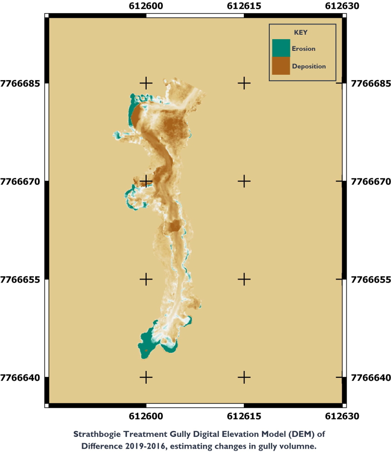
This record acts as an aggregation point for the datasets produced by NESP TWQ Project 2.1.4. for Gully Remediation at sites Meadowvale, Virginia Park, Strathbogie, Minnievale and Mt Wickham Station. These sites are located in the Burdekin Region of Queensland. The time series established in this project is being extended by NESP TWQ Project 5.9. Updated versions of this dataset will be linked to from this record when they become available.
There are two sites in the Upper Burdekin sites (Virginia Park and Meadowvale) which capitalize on previous research investments looking at rangeland management and water quality response. The Bogie (Strathbogie) and Don (Minnievale) sites are Reef Trust 2 partnership projects. Mt Wickham is a new site that is part of the Burdekin Landholders Driving Change (LDC) project.
Each contributing datasets has been described in specific dataset records linked as child records. Datasets include Key Localities, Loads Runoff, Site Configuration and survey types, TLS Scans and Analysis, Vegetation Survey, Water Quality survey. The data can be downloaded from each of the child records.
Simple
Identification info
- Date (Publication)
- 2019-08-22
- Cited responsible party
-
Role Organisation Name Telephone Delivery point City Administrative area Postal code Country Electronic mail address Principal investigator CSIRO Land and Water Bartley, Rebecca Dr Voice facsimile EcoSciences Precinct, 41 Boggo Road Dutton Park Queensland 4102 Australia rebecca.bartley@csiro.au Collaborator CSIRO Land and Water Henderson, Anne Voice facsimile Bld 145 ATSIPJames Cook University Douglas Queesnland 4812 Australia anne.henderson@csiro.au Collaborator CSIRO Land and Water Hawdon, Aaron Voice facsimile Bld 145 ATSIPJames Cook University Douglas Queensland 4810 Australia aaron.hawdon@csiro.au
- Point of contact
-
Role Organisation Name Telephone Delivery point City Administrative area Postal code Country Electronic mail address Point of contact CSIRO Land and Water Bartley, Rebecca Dr Voice facsimile EcoSciences Precinct, 41 Boggo Road Dutton Park Queensland 4102 Australia rebecca.bartley@csiro.au
- Topic category
-
- Biota
Extent
Extent
- Description
- Queensland Australia

Temporal extent
- Time period
- 2016-07-01 2018-06-30
Resource constraints
- Linkage
-
http://i.creativecommons.org/l/by/3.0/au/88x31.png
License Graphic
- Title
- Creative Commons Attribution 3.0 Australia License
- Cited responsible party
-
Role Organisation Name Telephone Delivery point City Administrative area Postal code Country Electronic mail address
- Website
-
http://creativecommons.org/licenses/by/3.0/au/
License Text
- Language
- English
- Character encoding
- UTF8
Distribution Information
- OnLine resource
- NESP TWQ Project page (Project reports and publications)
- OnLine resource
- eAtlas Web Mapping Service (WMS) (AIMS)
- OnLine resource
- Project web site
- OnLine resource
- Key Localities Gully Remediation (NESP TWQ 2.1.4, CSIRO)
- OnLine resource
- Site Configuration and Survey (NESP TWQ 2.1.4, CSIRO)
- OnLine resource
- Estimated Sediment Loads and Gully Runnoff for Restoration Effectiveness (NESP TWQ 2.1.4, CSIRO)
- OnLine resource
- nesp2:QLD_NESP-TWQ-2-1-4_CSIRO_Gully-remediation_Key-localities_20190702_Property_Boundaries
Metadata constraints
- Linkage
-
http://i.creativecommons.org/l/by/3.0/au/88x31.png
License Graphic
- Title
- Creative Commons Attribution 3.0 Australia License
- Cited responsible party
-
Role Organisation Name Telephone Delivery point City Administrative area Postal code Country Electronic mail address
- Website
-
http://creativecommons.org/licenses/by/3.0/au/
License Text
Metadata
- Metadata identifier
- urn:uuid/b8c71728-e988-4344-9d10-f0a8f5360201
- Language
- English
- Character encoding
- UTF8
- Contact
-
Role Organisation Name Telephone Delivery point City Administrative area Postal code Country Electronic mail address Point of contact Australian Institute of Marine Science (AIMS) eAtlas Data Manager Voice facsimile PRIVATE MAIL BAG 3, TOWNSVILLE MAIL CENTRE Townsville Queensland 4810 Australia e-atlas@aims.gov.au
Type of resource
- Resource scope
- Dataset
- Metadata linkage
-
https://eatlas.org.au/data/uuid/b8c71728-e988-4344-9d10-f0a8f5360201
Point of truth URL of this metadata record
- Date info (Creation)
- 2019-11-28T05:33:09
- Date info (Revision)
- 2023-10-11T01:04:10
Metadata standard
- Title
- ISO 19115-3:2018