eAtlas Data Catalogue
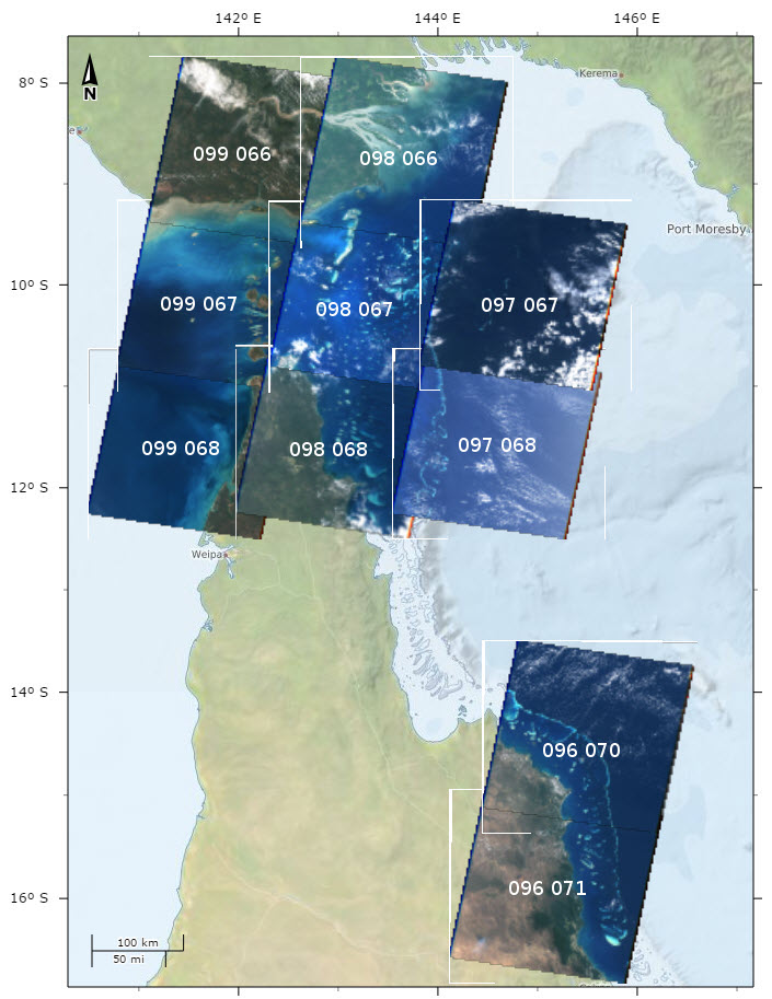
Landsat 5 Satellite Imagery for selected areas of Great Barrier Reef and Torres Strait (NERP TE 13.1, eAtlas AIMS, source: NASA)
This dataset contains Landsat 5 imagery for selected areas of Queensland, currently Torres Strait and around Lizard Island and Cape Tribulation.
This collection was made as a result of the development of the Torres Strait Features dataset. It includes a number (typically 4 - 8) of selected Landsat images for each scene from the entire Landsat 5 archive. These images were selected for having low cloud cover and clear water. The aim of this collection was to allow investigation of the marine features.
The complete catalogue of Landsat 5 for scenes 96_70, 96_71, 97_67, 97_68, 98_66, 98_67, 98_68_99_66, 99_67 and 99_68 were downloaded from the Google Earth Engine site ( https://console.developers.google.com/storage/earthengine-public/landsat/ ). The images were then processed into low resolution true colour using GDAL. They were then reviewed for picture clarity and the best ones were selected and processed at full resolution to be part of this collection.
The true colour conversion was achieved by applying level adjustment to each channel to ensure that the tonal scaling of each channel was adjusted to give a good overall colour balance. This effectively set the black point of the channel and the gain. This adjustment was applied consistently to all images.
- Red: Channel B3, Black level 8, White level 58
- Green: Channel B2, Black level 10, White level 55
- Blue: Channel B1, Black level 32, White level 121
Note: A constant level adjustment was made to the images regardless of the time of the year that the images were taken. As a result images in the summer tend to be brighter than those in the winter.
After level adjustment the three channels were merged into a single colour image using gdal_merge. The black surround on the image was then made transparent using the GDAL nearblack command.
This collection consists of 59 images saved as 4 channel (Red, Green, Blue, Alpha) GeoTiff images with LZW compression (lossless) and internal overviews with a WGS 84 UTM 54N projection.
Each of the individual images can be downloaded from the eAtlas map client (Overlay layers: eAtlas/Imagery Base Maps Earth Cover/Landsat 5) or as a collection of all images for each scene.
Data Location:
This dataset is filed in the eAtlas enduring data repository at: data\NERP-TE\13.1_eAtlas\QLD_NERP-TE-13-1_eAtlas_Landsat-5_1988-2011
Simple
Identification info
- Date (Publication)
- 2014-08-20T08:24:00
- Purpose
- This imagery was compiled to allow for mapping of reefs in Torres Strait.
- Credit
- NASA
- Status
- Completed
- Point of contact
-
Role Organisation Name Telephone Delivery point City Administrative area Postal code Country Electronic mail address Point of contact Australian Institute of Marine Science (AIMS) Lawrey, Eric, Dr Voice Facsimile PRIVATE MAIL BAG 3, TOWNSVILLE MAIL CENTRE Townsville Queensland 4810 Australia e-atlas@aims.gov.au
- Spatial representation type
- Grid
Spatial resolution
- Spatial resolution
- 30
- Topic category
-
- Imagery base maps earth cover
Extent
Extent
))
))
Temporal extent
- Time period
- 1988-09-01T09:52:00 2010-07-01T09:53:00
- Maintenance and update frequency
- As needed
Resource format
- Title
- GeoTiff
- Date
- File decompression technique
- LZW with internal overviews
- Keywords (Theme)
-
- marine
Resource constraints
- Linkage
-
http://i.creativecommons.org/l/by/3.0/au/88x31.png
License Graphic
- Title
- Creative Commons Attribution 3.0 Australia License
- Cited responsible party
-
Role Organisation Name Telephone Delivery point City Administrative area Postal code Country Electronic mail address
- Website
-
http://creativecommons.org/licenses/by/3.0/au/
License Text
- Language
- English
- Character encoding
- UTF8
Distribution Information
- OnLine resource
- eAtlas Web Mapping Service (WMS) (AIMS)
- OnLine resource
- Scene 098 066 (PNG, Fly River) [6 GeoTiff images, zipped] 484 MB
Reference System Information
- Reference system identifier
- EPSG/EPSG:32654
Metadata
- Metadata identifier
- urn:uuid/bc667743-3f77-4533-82a7-5b45c317dd89
- Language
- English
- Character encoding
- UTF8
- Contact
-
Role Organisation Name Telephone Delivery point City Administrative area Postal code Country Electronic mail address Point of contact Australian Institute of Marine Science (AIMS) eAtlas Data Manager Voice Facsimile PRIVATE MAIL BAG 3, TOWNSVILLE MAIL CENTRE Townsville Queensland 4810 Australia e-atlas@aims.gov.au
- Parent metadata
Type of resource
- Resource scope
- Dataset
- Metadata linkage
-
https://eatlas.org.au/data/uuid/bc667743-3f77-4533-82a7-5b45c317dd89
Point of truth URL of this metadata record
- Date info (Creation)
- 2017-12-18T13:06:34
- Date info (Revision)
- 2023-09-18T07:52:28
Metadata standard
- Title
- ISO 19115-3:2018