Marine satellite image test collections (AIMS)
This dataset consists of collections of satellite image composites (Sentinel 2 and Landsat 8) that are created from manually curated image dates for a range of projects. These images are typically prepared for subsequent analysis or testing of analysis algorithms as part of other projects. This dataset acts as a repository of reproducible test sets of images processed from Google Earth Engine using a standardised workflow.
Details of the algorithms used to produce the imagery are described in the GEE code and code repository available on GitHub ( https://github.com/eatlas/World_AIMS_Marine-satellite-imagery).
Project test image sets:
As new projects are added to this dataset, their details will be described here:
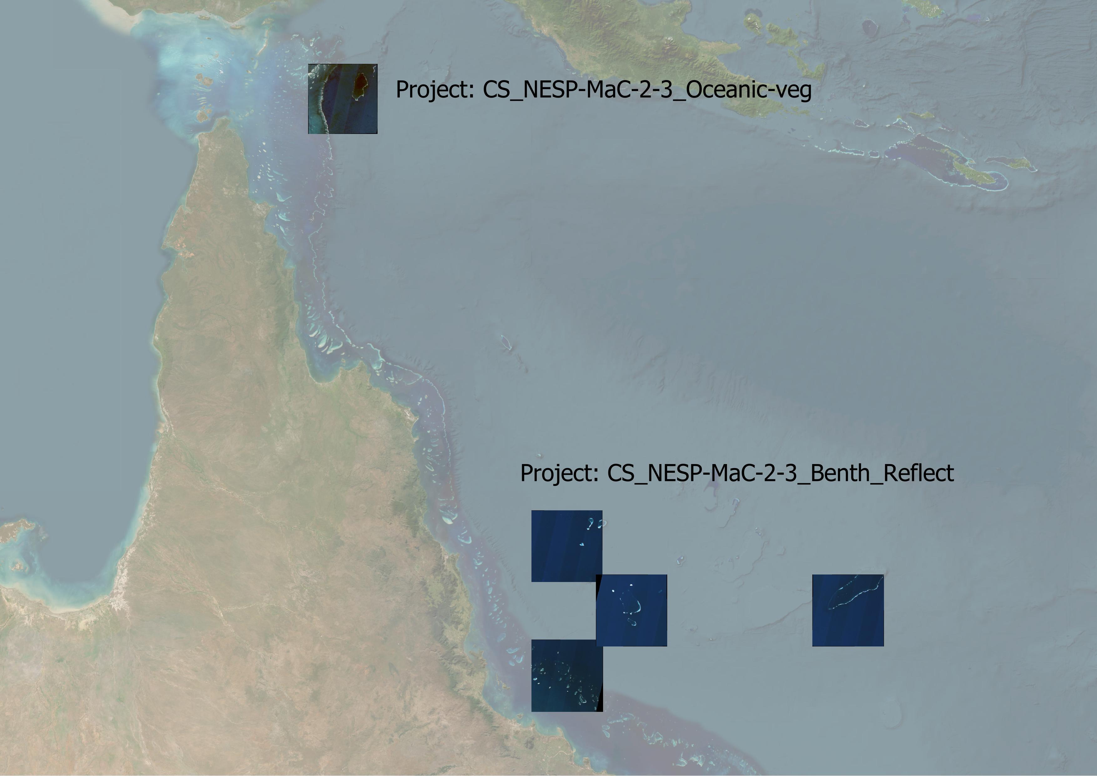
- NESP MaC 2.3 Benthic reflection estimation (projects/CS_NESP-MaC-2-3_AIMS_Benth-reflect):
This collection consists of six Sentinel 2 image composites in the Coral Sea and GBR for the purpose of testing a method of determining benthic reflectance of deep lagoonal areas of coral atolls. These image composites are in GeoTiff format, using 16-bit encoding and LZW compression. These images do not have internal image pyramids to save on space.
[Status: final and available for download]
- NESP MaC 2.3 Oceanic Vegetation (projects/CS_NESP-MaC-2-3_AIMS_Oceanic-veg):
This project is focused on mapping vegetation on the bottom of coral atolls in the Coral Sea. This collection consists of additional images of Ashmore Reef. The lagoonal area of Ashmore has low visibility due to coloured dissolved organic matter, making it very hard to distinguish areas that are covered in vegetation. These images were manually curated to best show the vegetation. While these are the best images in the Sentinel 2 series up to 2023, they are still not very good. Probably 80 - 90% of the lagoonal benthos is not visible.
[Status: final and available for download]
- NESP MaC 3.17 Australian reef mapping (projects/AU_NESP-MaC-3-17_AIMS_Reef-mapping):
This collection of test images was prepared to determine if creating a composite from manually curated image dates (corresponding to images with the clearest water) would produce a better composite than a fully automated composite based on cloud filtering. The automated composites are described in https://doi.org/10.26274/HD2Z-KM55. This test set also includes composites from low tide imagery. The images in this collection are not yet available for download as the collection of images that will be used in the analysis has not been finalised.
[Status: under development, code is available, but not rendered images]
- Capricorn Regional Map (projects/CapBunk_AIMS_Regional-map): This collection was developed for making a set of maps for the region to facilitate participatory mapping and reef restoration field work planning.
[Status: final and available for download]
- Default (project/default): This collection of manual selected scenes are those that were prepared for the Coral Sea and global areas to test the algorithms used in the developing of the original Google Earth Engine workflow. This can be a good starting point for new test sets. Note that the images described in the default project are not rendered and made available for download to save on storage space.
[Status: for reference, code is available, but not rendered images]
Filename conventions:
The images in this dataset are all named using a naming convention. An example file name is `Wld_AIMS_Marine-sat-img_S2_NoSGC_Raw-B1-B4_54LZP.tif`. The name is made up of:
- Dataset name (`Wld_AIMS_Marine-sat-img`), short for World, Australian Institute of Marine Science, Marine Satellite Imagery.
- Satellite source: `L8` for Landsat 8 or `S2` for Sentinel 2.
- Additional information or purpose: `NoSGC` - No sun glint correction, `R1` best reference imagery set or `R2` second reference imagery.
- Colour and contrast enhancement applied (`DeepFalse`, `TrueColour`,`Shallow`,`Depth5m`,`Depth10m`,`Depth20m`,`Raw-B1-B4`),
- Image tile (example: Sentinel 2 `54LZP`, Landsat 8 `091086`)
Limitations:
Only simple atmospheric correction is applied to land areas and as a result the imagery only approximates the bottom of atmosphere reflectance.
For the sentinel 2 imagery the sun glint correction algorithm transitions between different correction levels from deep water (B8) to shallow water (B11) and a fixed atmospheric correction for land (bright B8 areas). Slight errors in the tuning of these transitions can result in unnatural tonal steps in the transitions between these areas, particularly in very shallow areas.
For the Landsat 8 image processing land areas appear as black from the sun glint correction, which doesn't separately mask out the land. The code for the Landsat 8 imagery is less developed than for the Sentinel 2 imagery.
The depth contours are estimated using satellite derived bathymetry that is subject to errors caused by cloud artefacts, substrate darkness, water clarity, calibration issues and uncorrected tides. They were tuned in the clear waters of the Coral Sea. The depth contours in this dataset are RAW and contain many false positives due to clouds. They should not be used without additional dataset cleanup.
Change log:
As changes are made to the dataset, or additional image collections are added to the dataset then those changes will be recorded here.
2nd Edition, 2024-06-22: CapBunk_AIMS_Regional-map
1st Edition, 2024-03-18: Initial publication of the dataset, with CS_NESP-MaC-2-3_AIMS_Benth-reflect, CS_NESP-MaC-2-3_AIMS_Oceanic-veg and code for AU_NESP-MaC-3-17_AIMS_Reef-mapping and Default projects.
Data Format:
GeoTiff images with LZW compression. Most images do not have internal image pyramids to save on storage space. This makes rendering these images very slow in a desktop GIS. Pyramids should be added to improve performance.
Data Location:
This dataset is filed in the eAtlas enduring data repository at: data\custodian\2020-2029-AIMS\Wld-AIMS-Marine-sat-img
Simple
Identification info
- Date (Publication)
- 2024-03-18
- Date (Revision)
- 2024-06-22
Identifier
- Code
- 10.26274/zq26-a956
- Codespace
- doi.org
- Cited responsible party
-
Role Organisation Name Telephone Delivery point City Administrative area Postal code Country Electronic mail address Principal investigator Australian Institute of Marine Science (AIMS) Lawrey, Eric, Dr Townsville Queensland 4810 Australia e.lawrey@aims.gov.au Collaborator Australian Institute of Marine Science (AIMS) Hammerton, Marc Townsville Queensland 4810 Australia m.hammerton@aims.gov.au
- Purpose
- This image collection is intended to allow mapping of the reef and island features of the Coral Sea.
- Point of contact
-
Role Organisation Name Telephone Delivery point City Administrative area Postal code Country Electronic mail address Point of contact Australian Institute of Marine Science (AIMS) eAtlas Data Manager Voice Facsimile e-atlas@aims.gov.au Townsville Queensland 4810 Australia e-atlas@aims.gov.au
- Spatial representation type
- Grid
- Topic category
-
- Imagery base maps earth cover
Extent
Extent
- Description
- Coral Sea, Australia

Temporal extent
- Time period
- 2016-10-01 2021-09-20
- Keywords (Theme)
-
- Marine
Resource constraints
- Linkage
-
https://i.creativecommons.org/l/by/4.0/88x31.png
License Graphic
- Title
- Creative Commons Attribution 4.0 International License
- Alternate title
- CC-BY
- Edition
- 4.0
- Website
-
http://creativecommons.org/licenses/by/4.0/
License Text
- Other constraints
- Cite as: Lawrey, E., Hammerton, M. (2024). Marine satellite imagery test collections (AIMS) [Data set]. eAtlas. https://doi.org/10.26274/zq26-a956
- Language
- English
- Character encoding
- UTF8
Distribution Information
- OnLine resource
- Browse and download data
- OnLine resource
- Source code - Google Earth Engine and Python (GitHub)
- OnLine resource
-
Dataset and analysis using this dataset
Lawrey, E. (2024). Estimating benthic reflectance of deep coral atoll lagoons from satellite imagery and bathymetry - Analysis code and case studies (NESP MaC 2.3, AIMS) [Data set]. eAtlas.
Resource lineage
- Statement
- This code base is an extension of the scripts developed for the mapping of the Coral Sea ([Lawrey and Hammerton, 2022](https://doi.org/10.26274/NH77-ZW79)).
Metadata constraints
- Linkage
-
https://i.creativecommons.org/l/by/4.0/88x31.png
License Graphic
- Title
- Creative Commons Attribution 4.0 International License
- Alternate title
- CC-BY
- Edition
- 4.0
- Website
-
http://creativecommons.org/licenses/by/4.0/
License Text
Metadata
- Metadata identifier
- urn:uuid/db1cc6b1-47fb-4027-94e7-fc4f25183399
- Language
- English
- Character encoding
- UTF8
- Contact
-
Role Organisation Name Telephone Delivery point City Administrative area Postal code Country Electronic mail address Point of contact Australian Institute of Marine Science (AIMS) eAtlas Data Manager Voice Facsimile PRIVATE MAIL BAG 3, TOWNSVILLE MAIL CENTRE Townsville Queensland 4810 Australia e-atlas@aims.gov.au
Type of resource
- Resource scope
- Dataset
- Metadata linkage
-
https://eatlas.org.au/data/uuid/db1cc6b1-47fb-4027-94e7-fc4f25183399
Point of truth URL of this metadata record
- Date info (Revision)
- 2024-09-11T00:14:05.036Z
- Date info (Creation)
- 2024-03-12T03:18:41
Metadata standard
- Title
- ISO 19115-3:2018
Overviews
Spatial extent

Provided by
