eAtlas Data Catalogue
Marine wildlife management in the Northern Great Barrier Reef World Heritage Area - Spatial models of dugong distribution and relative density of aerial surveys from 1990 - 2013 (NERP TE 1.2, JCU)
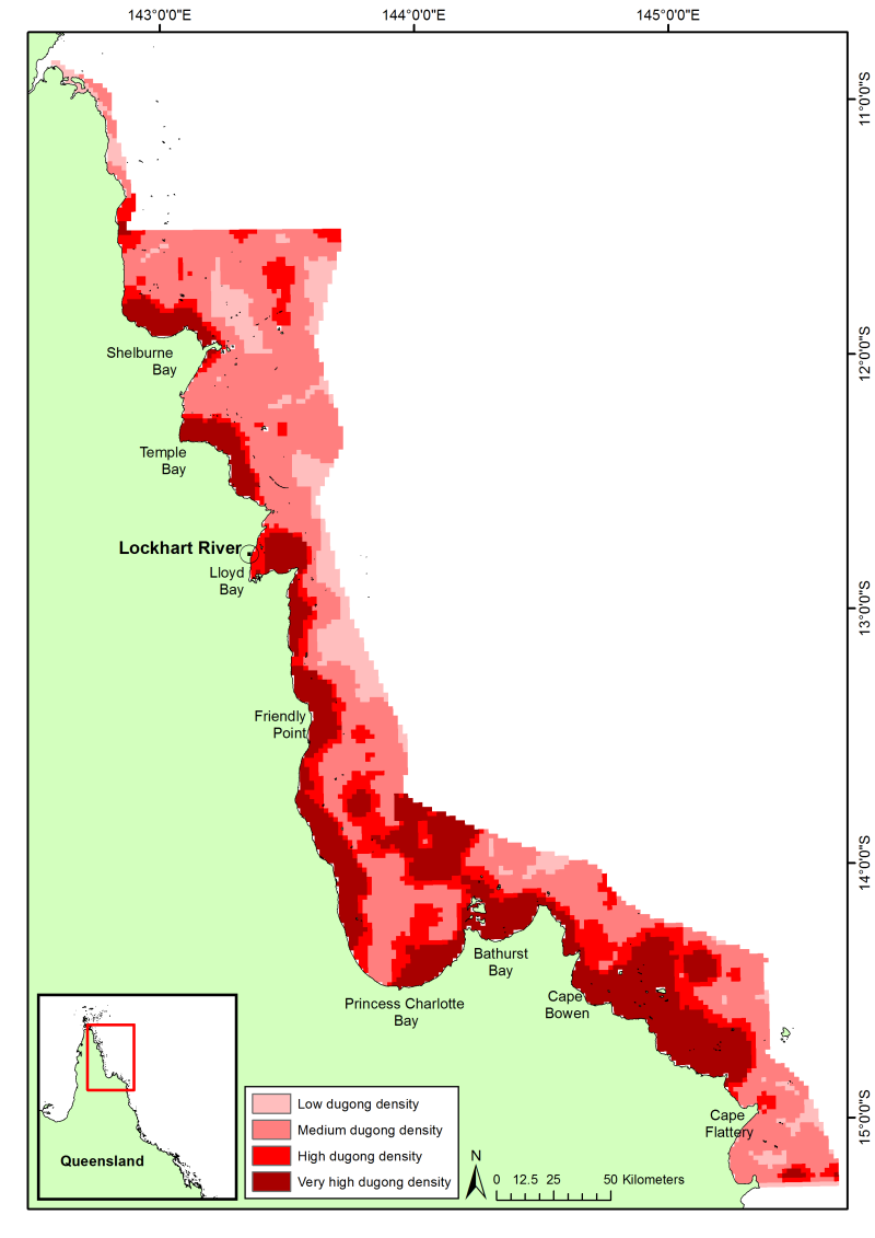
This dataset shows a raster spatial model of the distribution and relative density of dugongs (Dugong dugong) in the northern Great Barrier Reef region based on an aggregate of 24 years (1990 - 2013) of systematic aerial surveys.
Methods:
Aerial surveys were conducted using the strip transect method described by Marsh and Sinclair (1989). The survey region was divided into blocks containing systematic transects of varying length, which were typically perpendicular to the coast across the depth gradient. Tandem teams with two observers on each side of the aircraft independently recorded sightings of dugongs, including information on group size and calf numbers. Transects were 200 m wide at the water’s surface on either side of the aircraft.
The spatial data from all the aerial surveys in the region (1990, 1995, 2000, 2006, and 2013) were corrected for differences in sampling intensity and area sampled between surveys. For details on sampling intensities and areas, please refer to the reports and publications for each individual survey (list below). The corrected data were then interpolated using universal kriging over the spatial extent of the aerial surveys.
Planning units were 2km * 2km and were classified as low (1), medium (2), high (3) and very high (4) dugong density on the basis of the relative density of dugongs estimated from the model and a frequency analysis. Low density areas: 0 dugongs per square km; medium density areas 0.0015 - 0.25 dugongs per square km; high density areas 0.25 - 0.5 dugongs per square km; very high density areas > 0.5 dugongs per square km.
Limitations:
The modelled abundance and distribution show the relative density of dugongs (areas where there are more or less animals) and NOT the absolute dugong density as corrections for perception bias (animals that are available to, but missed by, observers) and availability bias (animals that are unavailable to observers because of water turbidity) can only be applied at the spatial scale of entire surveys (thousands of square kilometres), making them inappropriate for the spatial scale for this dataset. Nonetheless, the relative densities among regions should be approximately comparable (H. Marsh, personal communication).
Format:
The spatial model is 2481x3509 pixels with a spatial reference of WGS84 UTM Zone 54S. The original dataset is stored in ESRI GRID format (60 KB), which was converted to a GeoTiff for use in the eAtlas (134 kB). Both datasets are available under a creative commons attribution license.
References:
Publications for aerial surveys in the northern Great Barrier Reef:
Marsh, H. & Corkeron, P. (1996). The status of the dugong in the northern Great Barrier Reef. Report to Great Barrier Reef Marine Park Authority, Townsville.
Marsh, H. & Lawler, I. R. (2002). Dugong distribution and abundance in the Northern Great Barrier Reef Marine Park: November 2000. GBRMPA Research Publication 77. Townsville, Australia: Great Barrier Reef Marine Park Authority.
Marsh, H.D., Hodgson, A., Lawler, I., Grech, A., & Delean, S. (2007) Condition, status, and trends and projected futures of the dugong in the Northern Great Barrier Reef and Torres Strait; including identification and evaluation of the key threats and evaluation of available management options to improve its status. Marine and Tropical Sciences Research Facility Reports Series. Reef and Rainforest Research Centre Limited, Cairns (77pp.).
Data Location:
This dataset is filed in the eAtlas enduring data repository at: data\NERP-TE\1.2_GBR-Turtles-dugong-monitoing
Simple
Identification info
- Date (Publication)
- 2014-11-25
- Cited responsible party
-
Role Organisation Name Telephone Delivery point City Administrative area Postal code Country Electronic mail address Principal investigator James Cook University Hamann, Mark, Dr Voice James Cook University Townsville Queensland 4811 Australia Mark.Hamann@jcu.edu.au Principal investigator School of Earth and Environmental Sciences, James Cook University (JCU) Marsh, Helene, Prof. Voice facsimile James Cook University Townsville Queensland 4811 Australia helene.marsh@jcu.edu.au Collaborator Macquarie University Grech, Alana, Dr Voice facsimile Macquarie University Sydney New South Wales Australia Alana.Grech@mq.edu.au
- Point of contact
-
Role Organisation Name Telephone Delivery point City Administrative area Postal code Country Electronic mail address Point of contact School of Earth and Environmental Sciences, James Cook University (JCU) Marsh, Helene, Prof. Voice James Cook University Townsville Queensland 4811 Australia helene.marsh@jcu.edu.au
- Spatial representation type
- Vector
- Topic category
-
- Biota
Extent
Extent
- Description
- Great Barrier Reef, Australia

Temporal extent
- Time position
- 1990-01-01T00:00:00
- Time position
- 2013-12-31T00:00:00
- Keywords (Theme)
-
- marine
Resource constraints
- Linkage
-
http://i.creativecommons.org/l/by/3.0/au/88x31.png
License Graphic
- Title
- Creative Commons Attribution 3.0 Australia License
- Cited responsible party
-
Role Organisation Name Telephone Delivery point City Administrative area Postal code Country Electronic mail address
- Website
-
http://creativecommons.org/licenses/by/3.0/au/
License Text
- Language
- English
- Character encoding
- UTF8
Distribution Information
- OnLine resource
- Project web site
- OnLine resource
- Marsh H., et al. (2007). Condition, status and trends and projected futures of the dugong in the Northern Great Barrier Reef and Torres Strait
- OnLine resource
- Marsh H., Corkeron P. (1996). The status of the dugong in the northern Great Barrier Reef Marine Park.
- OnLine resource
- Marsh H., Corkeron P., Lawler I., Preen A. (1996). The Status of the Dugong in the Southern Great Barrier Reef Marine Park
- OnLine resource
- Marsh H., Lawler I. (2002). Dugong distribution and abundance in the northern Great Barrier Reef Marine Park - November 2000.
- OnLine resource
- Shapefiles, tiff and metadata record [ZIP 236 kB]
- OnLine resource
- Interactive map of this dataset
- OnLine resource
- nerp:NGBR_NERP-1-2_JCU_Dugong-density_Transects_1990-2013
- OnLine resource
- nerp:NGBR_NERP-1-2_JCU_Dugong-density_1990-2013
Resource lineage
- Hierarchy level
- Dataset
Metadata
- Metadata identifier
- urn:uuid/e2c6a628-f6cd-4789-917a-963577af8f95
- Language
- English
- Character encoding
- UTF8
- Contact
-
Role Organisation Name Telephone Delivery point City Administrative area Postal code Country Electronic mail address Point of contact Australian Institute of Marine Science (AIMS) eAtlas Data Manager Voice PRIVATE MAIL BAG 3, TOWNSVILLE MAIL CENTRE Townsville Queensland 4810 Australia e-atlas@aims.gov.au
- Parent metadata
Type of resource
- Resource scope
- Dataset
- Metadata linkage
-
https://eatlas.org.au/data/uuid/e2c6a628-f6cd-4789-917a-963577af8f95
Point of truth URL of this metadata record
- Date info (Creation)
- 2016-08-02T14:08:50
- Date info (Revision)
- 2023-09-18T07:08:58
Metadata standard
- Title
- ISO 19115-3:2018