eAtlas Data Catalogue
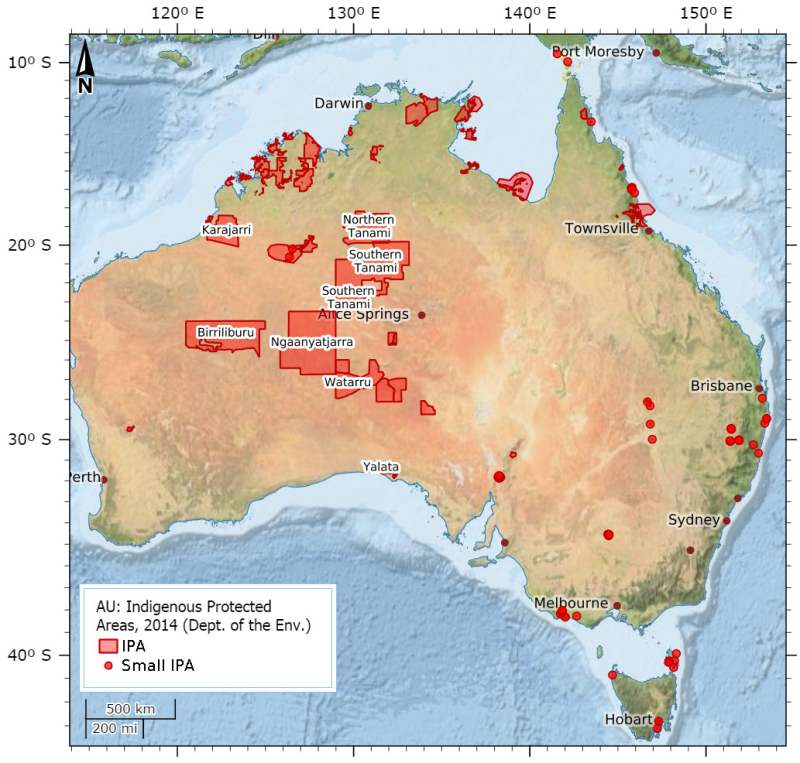
Indigenous Protected Areas (IPA) - Declared - April 2015 (Department of the Environment)
This dataset details the Declared Indigenous Protected Areas (IPA) across Australia through the implementation of the Indigenous Protected Areas Programme. These boundaries are not legally binding.
An Indigenous Protected Area (IPA) is an area of Indigenous-owned land or sea where traditional Indigenous owners have entered into an agreement with the Australian Government to promote biodiversity and cultural resource conservation.
The Indigenous Protected Areas element of the Caring for our Country initiative supports Indigenous communities to manage their land as IPAs, contributing to the National Reserve System. Further information can be found at the website below.
http://www.environment.gov.au/indigenous/ipa/index.html
Declared IPAs in order of gazettal date:
Nantawarrina
Preminghana
Risdon Cove
putalina
Deen Maar
Yalata
Warul Kawa
Watarru
Walalkara
Mount Chappell Island
Badger Island
Dhimurru
Guanaba
Wattleridge
Mount Willoughby
Paruku
Ngaanyatjarra
Tyrendarra
Toogimbie
Anindilyakwa
Laynhapuy - Stage 1
Ninghan
North Tanami
Warlu Jilajaa Jumu
Kaanju Ngaachi
Great Dog Island
Babel Island
lungatalanana
Angas Downs
Pulu Islet
Tarriwa Kurrukun
Warddeken
Djelk
Jamba Dhandan Duringala
Kurtonitj
Framlingham Forest
Kalka - Pipalyatjara
Boorabee and The Willows
Lake Condah
Marri-Jabin (Thamurrurr - Stage 1)
Brewarrina Ngemba Billabong
Uunguu - Stage 1
Apara - Makiri - Punti
Antara - Sandy Bore
Dorodong
Weilmoringle
Yanyuwa (Barni - Wardimantha Awara)
Minyumai
Gumma
Mandingalbay Yidinji
Southern Tanami
Angkum - Stage 1
Ngunya Jargoon
Birriliburu
Eastern Kuku Yalanji
Bardi Jawi
Girringun
Wilinggin
Dambimangari
Balanggarra
Thuwathu/Bujimulla
Yappala
Wardaman - Stage 1
Karajarri - Stage 1
Nijinda Durlga - Stage 1
Note: This record is a copy from the Department of the Environment for use in the eAtlas. For the latest version of this dataset check the Department of the Environment website.
Simple
Identification info
- Date (Creation)
- 2006-08-01T00:00:00
- Date (Revision)
- 2014-07-09T00:00:00
- Citation identifier
- Server=draco.ris; Service=5152; Version=SDE.DEFAULT; Dataset=PARKS_SDE.ipa_declared
- Cited responsible party
-
Role Organisation Name Telephone Delivery point City Administrative area Postal code Country Electronic mail address Custodian Australian Government Department of the Environment Voice Facsimile GPO Box 787 Canberra ACT 2601 parks.metadata@environment.gov.au Publisher Australian Government Department of the Environment Voice Facsimile GPO Box 787 CANBERRA ACT 2601 metadata@environment.gov.au
- Presentation form
- Digital map
- Credit
- When using this dataset for analysis or mapping you must always acknowledge the Indigenous Protected Areas Section, Parks Australia, Department of the Environment as the custodian of the data and also include the below copyright.
- Credit
- (c) Department of the Environment, 2014.
- Status
- On going
- Point of contact
-
Role Organisation Name Telephone Delivery point City Administrative area Postal code Country Electronic mail address Point of contact Australian Government Department of the Environment Voice Facsimile GPO Box 787 Canberra ACT 2601 parks.metadata@environment.gov.au
- Spatial representation type
- Vector
Spatial resolution
Equivalent scale
- Denominator
- 100000
- Topic category
-
- Boundaries
Extent
Extent
))
- Maintenance and update frequency
- As needed
Resource format
- Title
- SDE Feature Class
- Date
- Edition
- 1
- ANZLIC Search Words
-
- BOUNDARIES Cultural
- BOUNDARIES Administrative
- BOUNDARIES Administrative_Management
- Keywords
-
- Downloadable Data
Resource constraints
- Access constraints
- License
- Other constraints
- CC - Attribution (CC BY)
Resource constraints
- Access constraints
- License
- Other constraints
- Data to be available in the Public Domain under Creative Commons by Attribution Licensing Agreement. More information can be found here: http://creativecommons.org/licenses/by/3.0/au/deed.en
Resource constraints
- Use constraints
- License
- Other constraints
- It is the responsibility of the person using the IPA dataset to always check the metadata for the currency date within each jurisdiction and if required seek advice from the IPA Programme on details of more recent gazettals of protected areas. This dataset is unsuitable for use in any legal issue regarding boundaries. The land title authority in your area should be referred to for accurate and appropriate legal spatial data.
Resource constraints
- Access constraints
- Copyright
- Other constraints
- © Commonwealth of Australia (Department of the Environment) 2014
- Language
- English
- Character encoding
- UTF8
- Environment description
- Microsoft Windows 7 Version 6.1 (Build 7601) Service Pack 1; Esri ArcGIS 10.2.2.3552
- Supplemental Information
- published externally
Distribution Information
- Distribution format
-
- SDE Feature Class
Distributor
- Distributor contact
-
Role Organisation Name Telephone Delivery point City Administrative area Postal code Country Electronic mail address Distributor Australian Government Department of the Environment
- Title
- ArcGIS File geodatabase
- Date
- Edition
- 1
- Title
- Shapefile
- Date
- Edition
- 1
- OnLine resource
- 002
- OnLine resource
- Source: Indigenous Protected Areas (IPA) - Declared metadata and data (Department of the Environment)
- OnLine resource
- Interactive map of this dataset
- OnLine resource
- other-2015:AU_DotE_IPA-declared_2014
Data quality info
- Hierarchy level
- Dataset
Report
Result
- Title
- Absolute External Positional Accuracy Check
- Date (Revision)
- 2014-12-05T00:00:00
- Explanation
- Boundaries were either provided as spatial data, compiled using cadastral boundary, roads or rivers layers, digitized from hand drawn maps or plotted using textual descriptions. The accuracy of the boundaries copied from existing GIS data vary from less than 1m to 500m. The existing GIS data scale ranged from 1:1,000 (ACT) to 1:500,000 (northern WA).
- Pass
- true
Report
Result
- Title
- Non Quantitative Attribute Accuracy Check
- Date (Revision)
- 2014-12-05T00:00:00
- Explanation
- All anomolies were corrected by ERIN in consultation with the IPA Programme staff. Attributes in the IPA dataset are a subset of CAPAD attribute fields and are as follows: NAME: official (gazetted) name of a IPA or unofficial name. Gazetted IPA's with no name are flagged as "Unnamed". TYPE: official gazetted designation of the IPA. STATE: State the IPA is located in. STATUS: whether the IPA is declared or undeclared. GAZ_AREA: area of IPA in hectares as described in the nomination document (eg. parliamentary gazettal or nomination letter to the IPA Programme), to the nearest hectare. GIS_AREA: area of IPA in hectares as calculated in ArcGIS using the Australian Albers Equal Area projection. Where IPA's are made up of multiple polygons (parts) the GIS_AREA is the sum of all the polygons. IUCN: the IUCN protected area category described by the Managing authority, as outlined in the publication: CNPPA/WCMC "Guidelines for Protected Area management categories". Gland: IUCN, 1994. (ISBN: 2-8317-0201-1). IUCN Definitions include: IA Strict Nature Reserve: PA managed mainly for science; IB Wilderness Area: PA managed mainly for wilderness protection; II National Park: PA managed mainly for ecosystem protection; III Natural Monument: PA managed mainly for conservation of specific natural features; IV Habitat / Species Management Area: PA managed mainly for conservation through management intervention; V Protected Landscape / Seascape: PA managed mainly for landscape/seascape conservation and recreation; VI Managed Resource Protected Area: PA managed mainly for the sustainable use of natural ecosystems. AUTHORITY: This attribute contains code sets for the management authority of the IPA. Definitions include: IMG = Indigenous Management Group LILC = Local Indigenous Land Council TSRA = Torres Strait Regional Authority GAZ_DATE: original gazettal/ proclamation date. LATEST_GAZ: Date of most recent gazetted amendment or verification. ENVIRON: Where an IPA component comprises of land (T=terrestrial) or sea country (M=marine). SOURCE: Source of spatial dataset (eg. CAPAD_T). Definitions include: Cadlite = Cadastral parcels, as supplied by the Public Sector Mapping Authorities [PSMA] Cons = Consultant / Third party contractor CAPAD_T = Terrestrial component of CAPAD DLI = WA Land Information Authority (Landgate) DPIPWE = Tas Dept of Primary Industries, Parks, Water and Environment IMG = Indigenous Management Group NNTT = National Native Title Tribunal NRETAS = NT Dept of Land Resource Management (formerly the Dept of Natural Resources, Environment, the Arts and Sport) NRSP = National Reserve System Program, DSEWPaC COMMENTS: Any comments, change of name, etc
- Pass
- true
Report
Result
- Title
- Conceptual Consistency Check
- Date (Revision)
- 2014-12-05T00:00:00
- Explanation
- Attribute data conform to a subset of the nationally agreed CAPAD specifications. All source datasets which were not consistent with the CAPAD standards were corrected as required. Spatial data of source datasets were checked and corrected for mismatches across jurisdictional boundaries (see lineage for further details). All polygons were given visual checks for spatial errors and for appropriate attribute information.
- Pass
- true
Report
Result
- Title
- Completeness Omission Check
- Date (Revision)
- 2014-12-05T00:00:00
- Explanation
- All Declared IPA's are complete to the revision date of this dataset.
- Pass
- true
Resource lineage
- Statement
- The spatial boundaries were originally compiled by the NRS program and by ERIN since February 2009. Boundaries have been compiled as areas that have been declared through the IPA Programme. In 2006 ERIN revised the IPA dataset to align with the Collaborative Australian Protected Areas Database (CAPAD). This included modification of the spatial data to remove discrepancies as well as an attribution review for accuracy and completeness. This was undertaken with advice from the IPA Programme staff. Since February 2009 most boundaries have been sourced directly from the Indigenous Management Group (IMG) responsible for that IPA. Where this has occured it is marked in the Source field. Note: On occasions the spatial boundaries of declared IPA's may alter as new and more up-to-date mapping is made available from IMG's to ERIN. This will alter the GIS area (Ha) figure.
- Hierarchy level
- Dataset
Spatial representation info
- Topology level
- Geometry only
- Geometric object type
- Composite
- Geometric object count
- 70
Reference System Information
- Reference system identifier
- EPSG/4283
Metadata
- Metadata identifier
- urn:uuid/f16e1b55-afc6-44fb-8eae-413fb91ff727
- Language
- English
- Character encoding
- UTF8
- Contact
-
Role Organisation Name Telephone Delivery point City Administrative area Postal code Country Electronic mail address Point of contact Australian Government Department of the Environment Voice Facsimile GPO Box 787 Canberra ACT 2601 parks.metadata@environment.gov.au
Type of resource
- Resource scope
- Dataset
- Name
- dataset
- Metadata linkage
- https://eatlas.org.au/data/uuid/f16e1b55-afc6-44fb-8eae-413fb91ff727
- Date info (Revision)
- 2025-11-18T08:05:35.736Z
- Date info (Creation)
- 2022-03-10T04:41:25
Metadata standard
- Title
- ISO 19115-3:2018