eAtlas Data Catalogue
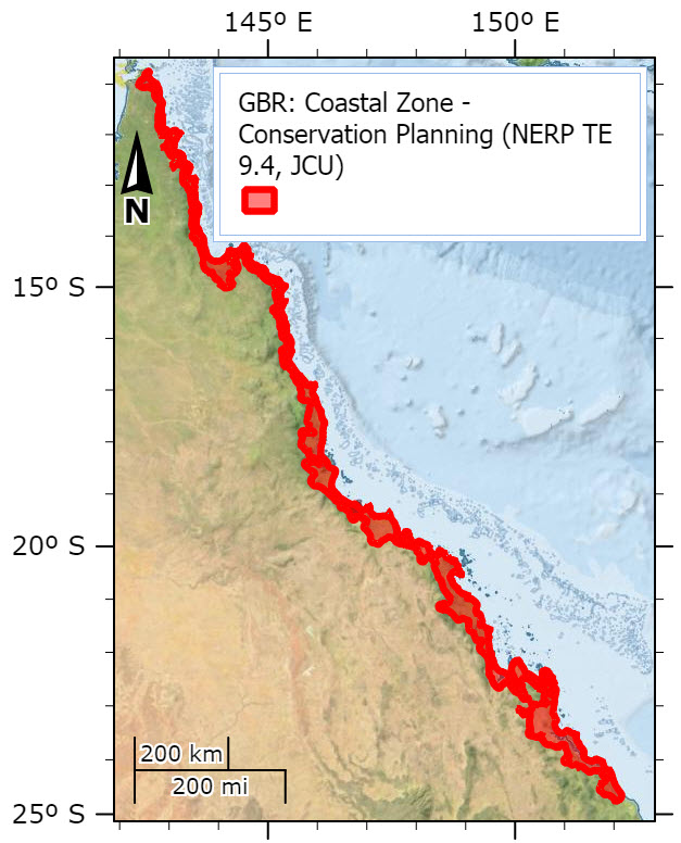
Extent of the Great Barrier Reef coastal zone for investigating coastal management and its impacts on marine life in the context of conservation planning (NERP TE 9.4, JCU)
This dataset contains the extent of the coastal zone for the Great Barrier Reef. This extent was identified as the most suitable area to be investigated on land and at sea as part of a conservation planning project looking at coastal development along the GBR coast.
Methods:
The terrestrial part of the coastal zone was initially defined in consultation with stakeholders and included the Queensland Government’s definition as “either: five kilometres from the coastline; or where land first reaches the height of 10 metres Australian Height Datum (AHD), whichever is further from the coast” (Queensland Coastal Management Plan). However, the Queensland government definition corresponds to a narrow strip of coastline in most areas and does not encompass most of coastal land uses (and their potential future expansion) that have a significant impact on the marine environmental such as agriculture. In the context of biodiversity conservation and water quality, workshop participants were asked what the coastal zone meant to them. The answers were summarised into four main categories:
1- Intensive coastal-based agriculture,
2- Geomorphological characteristics,
3- Typical coastal vegetation, and
4- Human presence and activities.
The coastal zone was defined to include all features that would match these four categories, and that also included the Government’s definition. The marine part of the coastal zone was also defined during this process and the offshore boundary was described as the maximum flood plume extent (secondary flood plume) as in Álvarez-Romero et al. 2013. The extent was smoothed to allow a clear area to be defined. This covers the areas that are have the greatest level of impacts from coastal development, in particular from run-off.
Format:
GBR_coastal_zone.shp (and all associated files as part of the shapefile)
This dataset contains a polygon that defines the extent of the area identified as the most appropriate coastal zone of the Great Barrier Reef to investigate conservation planning, in particular spatial planning of coastal development to ensure the health for the GBR World Heritage Area.
References:
Álvarez-Romero, J. G., M. Devlin, E. Teixeira da Silva, C. Petus, N. C. Ban, R. L. Pressey, J. Kool, J. J. Roberts, S. Cerdeira-Estrada, and A. S. Wenger. 2013. A novel approach to model exposure of coastal-marine ecosystems to riverine flood plumes based on remote sensing techniques. Journal of environmental management 119:194-207.
Simple
Identification info
- Date (Publication)
- 2015-01-19
- Cited responsible party
-
Role Organisation Name Telephone Delivery point City Administrative area Postal code Country Electronic mail address Principal investigator Australian Research Council Centre of Excellence for Coral Reef Studies (JCU) Augé, Amélie, Dr Voice James Cook University Townsville Queensland 4811 Australia amelie.auge@jcu.edu.au Collaborator Australian Research Council Centre of Excellence for Coral Reef Studies (JCU) Pressey, Bob, Prof. Voice James Cook University Townsville Queensland 4811 Australia bob.pressey@jcu.edu.au
- Point of contact
-
Role Organisation Name Telephone Delivery point City Administrative area Postal code Country Electronic mail address Point of contact Australian Research Council Centre of Excellence for Coral Reef Studies (JCU) Augé, Amélie, Dr Voice James Cook University Townsville Queensland 4811 Australia amelie.auge@jcu.edu.au
- Spatial representation type
- Vector
- Topic category
-
- Boundaries
Extent
Extent
- Description
- Coastal zone

Resource constraints
- Linkage
-
http://i.creativecommons.org/l/by/3.0/au/88x31.png
License Graphic
- Title
- Creative Commons Attribution 3.0 Australia License
- Cited responsible party
-
Role Organisation Name Telephone Delivery point City Administrative area Postal code Country Electronic mail address
- Website
-
http://creativecommons.org/licenses/by/3.0/au/
License Text
- Language
- English
- Character encoding
- UTF8
Distribution Information
- OnLine resource
- Project web site
- OnLine resource
- eAtlas Web Mapping Service (WMS) (AIMS)
- OnLine resource
- Coastal zone shapefile. [Zip 1.5 MB]
- OnLine resource
- nerp:GBR_NERP-TE-9-4_JCU_Coastal-zone
- OnLine resource
- Interactive map of this dataset
Metadata constraints
- Linkage
-
http://i.creativecommons.org/l/by/3.0/au/88x31.png
License Graphic
- Title
- Creative Commons Attribution 3.0 Australia License
- Cited responsible party
-
Role Organisation Name Telephone Delivery point City Administrative area Postal code Country Electronic mail address
- Website
-
http://creativecommons.org/licenses/by/3.0/au/
License Text
Metadata
- Metadata identifier
- urn:uuid/f49c5d09-3c50-4d0c-b779-f2dd3642bfcf
- Language
- English
- Character encoding
- UTF8
- Contact
-
Role Organisation Name Telephone Delivery point City Administrative area Postal code Country Electronic mail address Point of contact Australian Institute of Marine Science (AIMS) eAtlas Data Manager Voice facsimile PRIVATE MAIL BAG 3, TOWNSVILLE MAIL CENTRE Townsville Queensland 4810 Australia e-atlas@aims.gov.au
- Parent metadata
Type of resource
- Resource scope
- Dataset
- Metadata linkage
-
https://eatlas.org.au/data/uuid/f49c5d09-3c50-4d0c-b779-f2dd3642bfcf
Point of truth URL of this metadata record
- Date info (Creation)
- 2015-01-20T14:58:58
- Date info (Revision)
- 2023-09-18T07:00:55
Metadata standard
- Title
- ISO 19115-3:2018