eAtlas Data Catalogue
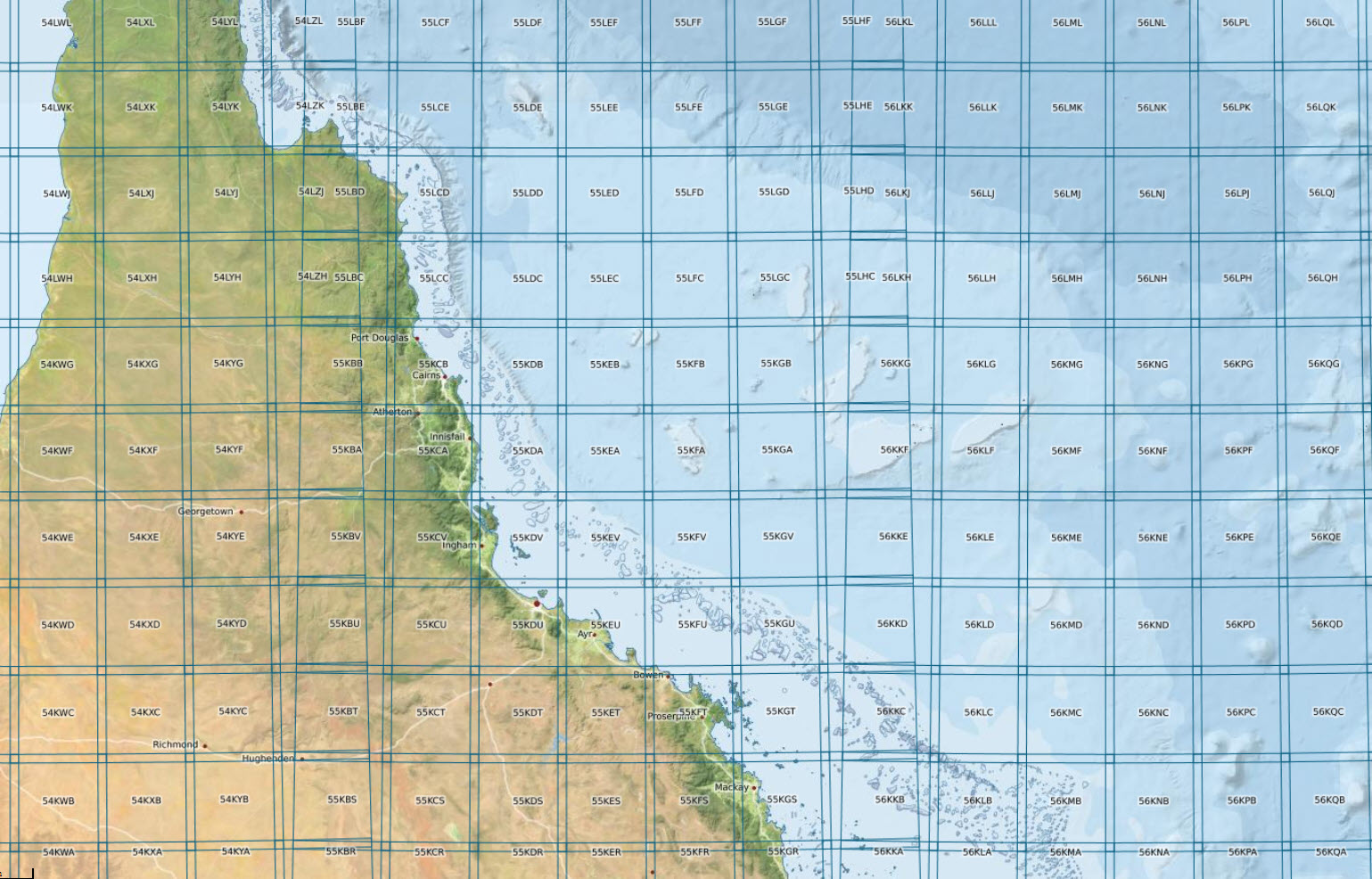
Sentinel-2 UTM Tiling Grid (ESA)
This dataset shows the tiling grid and their IDs for Sentinel 2 satellite imagery. The tiling grid IDs are useful for selecting imagery of an area of interest.
Sentinel 2 is an Earth observation satellite developed and operated by the European Space Agency (ESA). Its imagery has 13 bands in the visible, near infrared and short wave infrared part of the spectrum. It has a spatial resolution of 10 m, 20 m and 60 m depending on the spectral band.
Sentinel-2 has a 290 km field of view when capturing its imagery. This imagery is then projected on to a UTM grid and made available publicly on 100x100 km2 tiles. Each tile has a unique ID. This ID scheme allows all imagery for a given tile to be located.
Provenance:
The ESA make the tiling grid available as a KML file (see links). We were, however, unable to convert this KML into a shapefile for deployment on the eAtlas. The shapefile used for this layer was sourced from the Git repository developed by Justin Meyers ( https://github.com/justinelliotmeyers/Sentinel-2-Shapefile-Index).
Why is this dataset in the eAtlas?:
Sentinel 2 imagery is very useful for the studying and mapping of reef systems. Selecting imagery for study often requires knowing what the tile grid IDs are for the area of interest. This dataset is intended as a reference layer. The eAtlas is not a custodian of this dataset and copies of the data should be obtained from the original sources.
Data Dictionary:
- Name: UTM code associated with each tile. For example 55KDV
Simple
Identification info
- Date (Publication)
- 2016-02-01
- Cited responsible party
-
Role Organisation Name Telephone Delivery point City Administrative area Postal code Country Electronic mail address Processor Meyers, Justin Voice Facsimile
- Point of contact
-
Role Organisation Name Telephone Delivery point City Administrative area Postal code Country Electronic mail address Point of contact Australian Institute of Marine Science (AIMS) eAtlas Data Manager Voice Facsimile PRIVATE MAIL BAG 3, TOWNSVILLE MAIL CENTRE Townsville Queensland 4810 Australia e-atlas@aims.gov.au
- Spatial representation type
- Vector
- Topic category
-
- Imagery base maps earth cover
Extent
Extent
- Description
- World
))
Resource constraints
- Linkage
-
http://i.creativecommons.org/l/by/3.0/au/88x31.png
License Graphic
- Title
- Creative Commons Attribution 3.0 Australia License
- Cited responsible party
-
Role Organisation Name Telephone Delivery point City Administrative area Postal code Country Electronic mail address
- Website
-
http://creativecommons.org/licenses/by/3.0/au/
License Text
- Language
- English
- Character encoding
- UTF8
Distribution Information
- OnLine resource
- eAtlas Web Mapping Service (WMS) (AIMS)
- OnLine resource
- Interactive map of this dataset
- OnLine resource
- ref:World_ESA_Sentinel-2-tiling-grid_Poly
- OnLine resource
- Sentinel-2 tiling grid in KML format [KML 106 MB]
Metadata constraints
- Linkage
-
http://i.creativecommons.org/l/by/3.0/au/88x31.png
License Graphic
- Title
- Creative Commons Attribution 3.0 Australia License
- Cited responsible party
-
Role Organisation Name Telephone Delivery point City Administrative area Postal code Country Electronic mail address
- Website
-
http://creativecommons.org/licenses/by/3.0/au/
License Text
Metadata
- Metadata identifier
- urn:uuid/f7468d15-12be-4e3f-a246-b2882a324f59
- Language
- English
- Character encoding
- UTF8
- Contact
-
Role Organisation Name Telephone Delivery point City Administrative area Postal code Country Electronic mail address Point of contact Australian Institute of Marine Science (AIMS) eAtlas Data Manager Voice Facsimile PRIVATE MAIL BAG 3, TOWNSVILLE MAIL CENTRE Townsville Queensland 4810 Australia e-atlas@aims.gov.au
Type of resource
- Resource scope
- Dataset
- Metadata linkage
-
https://eatlas.org.au/data/uuid/f7468d15-12be-4e3f-a246-b2882a324f59
Point of truth URL of this metadata record
- Date info (Creation)
- 2020-10-20T13:35:37
- Date info (Revision)
- 2026-06-25T09:22:46.015Z
Metadata standard
- Title
- ISO 19115-3:2018