eAtlas Data Catalogue
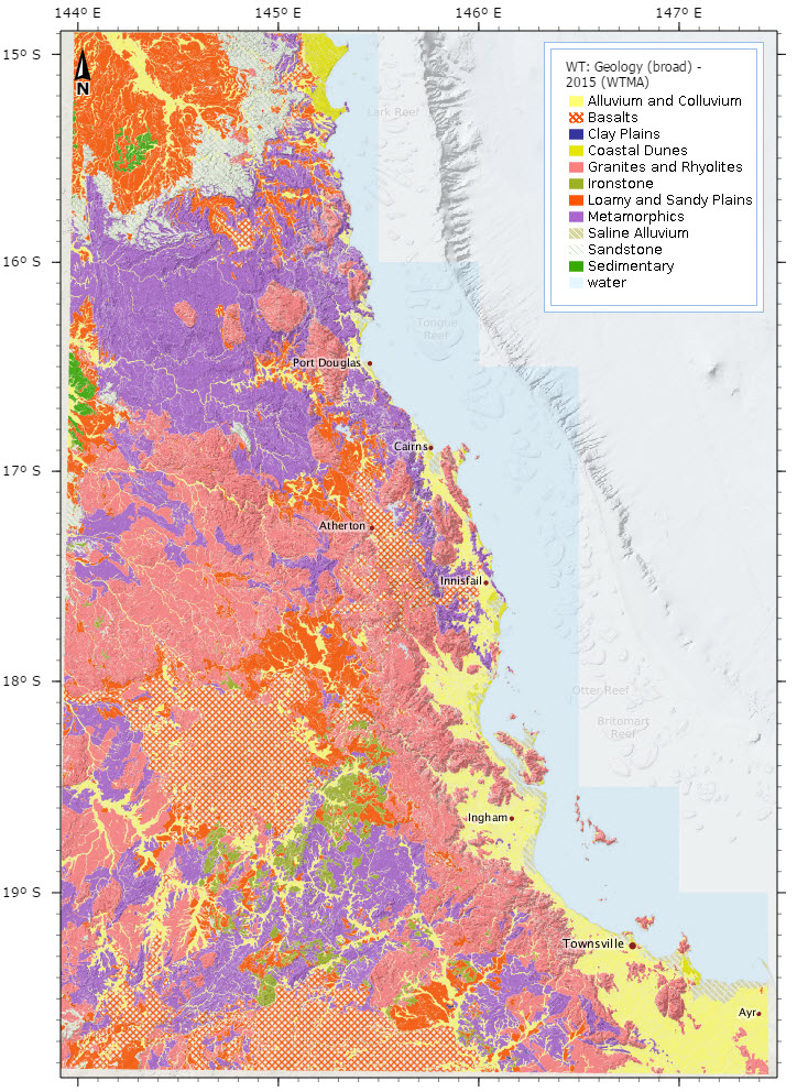
Broad Geology of Wet Tropics of Queensland - 2015 (WTMA)
This dataset shows the broad geology of the Wet Tropics of Queensland and surrounding areas from Ayr up to north of Cooktown. It is a combination of the "Geology of the Wet Tropics Bioregion (WTMA)" dataset (WtmaGeology) from the Vegetation mapping of the Wet Tropics and the state wide Regional Ecosystem mapping by the Queensland Government.
Whilst the WtmaGeology dataset provided high resolution mapping of geology in the Wet Tropics Bioregion it only provided geology where there was remnant vegetation. As a result cleared and regrowth areas were not assigned a geology type. This dataset resolves this problem by filling in these areas with geology information extracted from the Regional Ecosystem mapping. In addition to this the Regional Ecosystem mapping data was used to expand the coverage outside the Wet Tropics Bioregion to provide a continuity with the adjoining Bioregions. To maintain compatibility compatibility between the two sources of mapping some of the WtmaGeology classifications were grouped. As a result this dataset has broader classifications then the WtmaGeology dataset.
The geology in this dataset has the following classifications:
Geology - Landzone
* Saline Alluvium - 1
* Coastal Dunes- 2
* Alluvium and Colluvium - 3
* Clay Plains - 4
* Loamy and Sandy Plains - 5
* Ironstone - 7
* Basalts - 8
* Sedimentary - 9
* Sandstone - 10
* Metamorphics - 11
* Granites and Rhyolites - 12
* water
More information about each of the geology classifications can be found in the Land Zone descriptions - https://www.qld.gov.au/environment/plants-animals/plants/ecosystems/land-zones/ .
The geology from the Regional Ecosystem mapping was extracted using the following process. The Landzone was extracted from the Pre-clearing regional ecosystems mapping; thence the Broad Geology was determined from the Landzone descriptions - General term. General term was kept consistent as possible with the geology descriptors in the WtmaGeology coverage. The major discrepancies would be for geology described outside of the Bioregion of the Wet Tropics, such as Desert Uplands or Brigalow Belt.
Background information on the Regional Ecosystem source data:
Pre-clearing regional ecosystems mapping was developed at a map scale of 1:100,000 and 1:50,000 the in the Bioregion of the Wet Tropics, based on surveys of vegetation communities and related landform, soils and geology and on 1:80,000 B&W 1960-1993 aerial photography.
The survey and mapping of regional ecosystems of Queensland provides information for regional groups, non-government organisations, government departments, local government and industry, for planning and management purposes. (Dataset for Queensland incomplete). The major discrepancies would be for geology described outside of the Bioregion of the Wet Tropics, such as Desert Uplands or Brigalow Belt. The pre-clearing mapping is based on aerial photography and field survey of vegetation communities. Regional ecosystem linework reproduced at a scale greater than 1:100,000, except in designated areas, should be used as a guide only.
Version 7.0 regional ecosystem descriptions, as originally described in Sattler & Williams (ed.) (1999) is available for download on the website: http://www.ehp.qld.gov.au/ecosystems/biodiversity/regional
-ecosystems/how_to_download_redd.html (Regional Ecosystem Description Database).
Format:
This dataset is available in two formats: a ArcGIS Shapefile (249 MB) and and ArcGIS File Geodatabase (100 MB).
Simple
Identification info
- Date (Publication)
- 2015-03-28
- Point of contact
-
Role Organisation Name Telephone Delivery point City Administrative area Postal code Country Electronic mail address Point of contact Wet Tropics Management Authority (WTMA) WTMA - GIS Project Manager Voice facsimile Level 1, 15 Lake St Townsville Queensland 4810 Australia e-atlas@aims.gov.au
- Spatial representation type
- Vector
Spatial resolution
Equivalent scale
- Denominator
- 100000
- Topic category
-
- Geoscientific information
Extent
Extent
- Description
- Wet Tropics, Queensland

Temporal extent
- Time position
- 2012-03-26T00:00:00
- Time position
- 2015-03-01T00:00:00
Resource constraints
- Use limitation
- Subject to standard Data Transfer Agreement. PUBLIC Access - The conditions of use are detailed in the data usage license between the Custodian and the Recipient. No third party usage is permitted other than indicated in the agreement. Charges for the supply of digital data may apply.
- Language
- English
- Character encoding
- UTF8
Distribution Information
- OnLine resource
- Geology of the Wet Tropics Bioregion (WTMA) dataset.
- OnLine resource
- Land zone definitions (QLD Gov)
- OnLine resource
- Interactive map of this dataset
- OnLine resource
- eAtlas Web Mapping Service (WMS) (AIMS)
- OnLine resource
- wtma:WT_WTMA_Geology-broad_2015
Resource lineage
- Statement
- Data derived from the pre-clearing regional ecosystem mapping from the Department of Environment and Heritage Protection. Scale varying from 1:50000 within the bioregion of the wet tropics to 1:100000 outside the bioregion of the wet tropics. The Wtma geology coverage associated with the Vegetation of the Wet Tropics mapping is only described where there is remnant vegetation. i.e. cleared and regrowth areas where not assigned a geology type. Hence this Broad Geology coverage fills a gap in the WtmaGeolgy coverage based on the Vegetation of the Wet Tropics coverage. This then provides a continuity with the adjoining Bioregions. The Landzone was extracted from the Pre-clearing regional ecosystems mapping; thence the Broad Geology was determined from the Landzone descriptions - General term. General term was kept consistent as possible with the geology descriptors in the WtmaGeology coverage. The major discrepancies would be for geology described outside of the Bioregion of the Wet Tropics, such as Desert Uplands or Brigalow Belt.
- Hierarchy level
- Dataset
Metadata constraints
- Linkage
-
http://i.creativecommons.org/l/by/3.0/au/88x31.png
License Graphic
- Title
- Creative Commons Attribution 3.0 Australia License
- Cited responsible party
-
Role Organisation Name Telephone Delivery point City Administrative area Postal code Country Electronic mail address
- Website
-
http://creativecommons.org/licenses/by/3.0/au/
License Text
Metadata
- Metadata identifier
- fa849a28-0fde-4d10-93f1-f612b217fac1
- Language
- English
- Character encoding
- UTF8
- Contact
-
Role Organisation Name Telephone Delivery point City Administrative area Postal code Country Electronic mail address Point of contact Australian Institute of Marine Science (AIMS) eAtlas Data Manager Voice facsimile PRIVATE MAIL BAG 3, TOWNSVILLE MAIL CENTRE Townsville Queensland 4810 Australia e-atlas@aims.gov.au
Type of resource
- Resource scope
- Dataset
- Metadata linkage
-
https://eatlas.org.au/data/uuid/fa849a28-0fde-4d10-93f1-f612b217fac1
Point of truth URL of this metadata record
- Date info (Creation)
- 2015-03-31T12:17:26
- Date info (Revision)
- 2015-03-31T12:17:26
Metadata standard
- Title
- ISO 19115-3:2018