eAtlas Data Catalogue
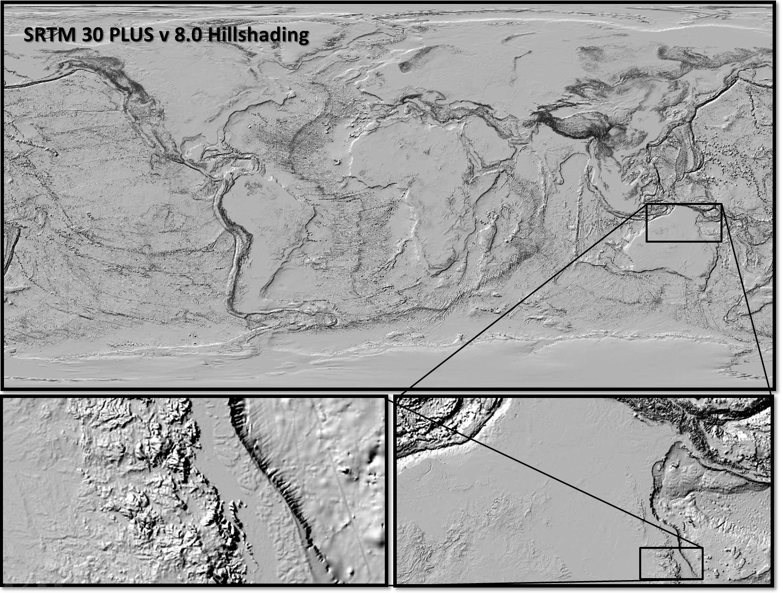
Global hillshading from SRTM30_PLUS v8.0 (NERP TE 13.1 eAtlas, source: UCSD)
This dataset consists reprocessing and reformatting the SRTM30 PLUS v8.0 Digital Elevation Model (DEM) dataset developed by Scripps Institute Of Oceanography, University of California San Diego (UCSD) to produce a single raster covering the globe in GeoTiff format and create a full and low resolution hillshading from this DEM. The aim of this derived dataset is to reformat the data to allow easy use with GIS applications.
Full resolution hillshading:
The hillshading was produced by combining the 33 source DEMs using gdal_translate then processing using gdaldem with a z-factor of 0.0001. This output was then formatted as a JPEG compressed GeoTiff file with internal overviews (World_e-Atlas-UCSD_SRTM30-plus_v8_Hillshading.tif).
Low resolution smoothed hillshading:
A lower resolution of the hillshading (World_e-Atlas-UCSD_SRTM30-plus_v8_Hillshading-lr.tif) was also produced for for use when displaying zoomed out global maps. By making the hillshading smoother the bulk features (mountain ranges, etc) are easier to see.
This was generated by subsampling the DEM by two times (down to 21600x10800 pixels) then smoothing it with a pixel Gaussian filter. This was achieved using gdalwarp to subsample the data. Gdalbuildvrt was then used to create a virtual dataset that included a 4 pixel Gaussian filter kernel. The hillshading was then applied to this filtered data source using gdaldem with a z-factor of 0.0003, which 3 times stronger than the high resolution version of this dataset.
Simple
Identification info
- Date (Publication)
- 2013-07-31T10:30:00
- Status
- Completed
- Point of contact
-
Role Organisation Name Telephone Delivery point City Administrative area Postal code Country Electronic mail address Principal investigator Australian Institute of Marine Science (AIMS) Lawrey, Eric, Dr Voice Facsimile PRIVATE MAIL BAG 3, TOWNSVILLE MAIL CENTRE Townsville Queensland 4810 Australia e-atlas@aims.gov.au
- Spatial representation type
- Grid
Spatial resolution
Equivalent scale
- Denominator
- 2000000
- Topic category
-
- Elevation
Extent
Extent
))
- Keywords (Theme)
-
- marine
Resource constraints
- Linkage
-
http://i.creativecommons.org/l/by/2.5/au/88x31.png
License Graphic
- Title
- Creative Commons Attribution 2.5 Australia License
- Cited responsible party
-
Role Organisation Name Telephone Delivery point City Administrative area Postal code Country Electronic mail address
- Website
-
http://creativecommons.org/licenses/by/2.5/au/
License Text
- Language
- English
- Character encoding
- UTF8
Distribution Information
- OnLine resource
- SRTM PLUS Global Topography page (UCSD).
- OnLine resource
- World_e-Atlas-UCSD_SRTM30-plus_v8_Hillshading.tif (43200 x 21600 pixels, GeoTiff with overviews, 263 MB)
- OnLine resource
- World_e-Atlas-UCSD_SRTM30-plus_v8_Hillshading-lr.tif (Smoothed Lower resolution: 21600 x 10800 pixels, GeoTiff with overviews, 81 MB)
- OnLine resource
- Interactive map of this dataset
- OnLine resource
- ea-be:World_e-Atlas-UCSD_SRTM30-plus_v8_Hillshading
- OnLine resource
- ea-be:World_e-Atlas-UCSD_SRTM30-plus_v8_Hillshading-lr
- OnLine resource
- eAtlas Web Mapping Service (WMS) (AIMS)
- OnLine resource
- eAtlas project page
Reference System Information
- Reference system identifier
- EPSG/EPSG:4326
Metadata
- Metadata identifier
- urn:uuid/239c5d24-f141-4cba-8311-aa43b46ef701
- Language
- English
- Character encoding
- UTF8
- Contact
-
Role Organisation Name Telephone Delivery point City Administrative area Postal code Country Electronic mail address Point of contact Australian Institute of Marine Science (AIMS) eAtlas Data Manager Voice Facsimile PRIVATE MAIL BAG 3, TOWNSVILLE MAIL CENTRE Townsville Queensland 4810 Australia e-atlas@aims.gov.au
Type of resource
- Resource scope
- Dataset
- Metadata linkage
-
https://eatlas.org.au/data/uuid/239c5d24-f141-4cba-8311-aa43b46ef701
Point of truth URL of this metadata record
- Date info (Creation)
- 2015-07-01T20:49:40
- Date info (Revision)
- 2023-09-18T08:49:13
Metadata standard
- Title
- ISO 19115-3:2018